Brohl-Lützing geodata
Brohl-Lützing (Rheinland-Pfalz) is a seat of a fourth-order administrative division; located in Germany in Europe/Berlin (GMT+2) time zone. With population of 2,654 people, there are 4276 cities with bigger population in this country. Compared to other cities in Germany, 53.2% of cities are located further ↑North; 89.6% of cities are located further →East and 75% of cities have higher elevation than Brohl-Lützing. Note1
Administrative division(s):
- Level 1: Rheinland-Pfalz
- Level 3: Landkreis Ahrweiler
- Level 4: Brohl-Lützing


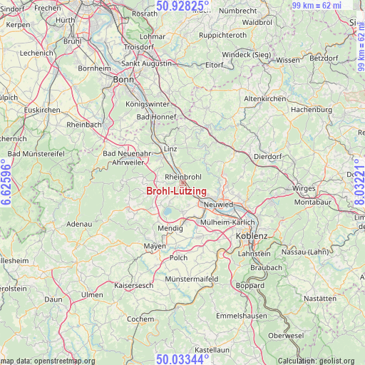
Brohl-Lützing GPS coordinates[2]
50° 28' 58.656" North, 7° 19' 44.688" East
| Map corner | latitude | longitude |
|---|---|---|
| Upper-left | 50.92825°, | 6.62596° |
| Center: | 50.48296°, | 7.32908° |
| Lower-right: | 50.03344°, | 8.03221° |
| Map W x H: | 99.5×99.5 km | = 61.8×61.8mi |
| max Lat: | 55.01917° ⇑53.2% North |
| Brohl-Lützing: | 50.48296° |
| min Lat: | ⇓46.8% South 47.40724° |
| min Long | Brohl-Lützing | max Long |
| 5.92978° | 7.32908° | 14.98853° |
| W 10.4%⇐ | ⇒89.6% E |
Elevation
Elevation of Brohl-Lützing is 63 m = 207 ft, and this is 186.1 m = 611 ft below average elevation for this country.
| Max E: |
1256 m = 4121 ft | 75% |
| Avg. | 249.1 m = 817 ft | |
| Brohl-Lützing | 63 m = 207 ft | |
Min E: |
-5 m = -16 ft | 25% |
See also: Germany elevation on elevation.city.
Geographical zone
Brohl-Lützing is located in North temperate zone (between Tropic of Cancer and the Arctic Circle). Distance of this North polar circle is 1788 km =1111 mi to North.| Distance of | km | miles | from Brohl-Lützing |
|---|---|---|---|
| North Pole | 4393.9 | 2730.2 | to North |
| Arctic Circle | 1788 | 1111 | to North |
| Tropic Cancer | 3007.3 | 1868.6 | to South |
| Equator | 5613.2 | 3487.9 | to South |


Nearby cities:
15 places around Brohl-Lützing: (largest is in red/bold)
• Andernach
7.8 km =4.8 mi,  137°
137°
• Bad Breisig
3.8 km =2.4 mi,  310°
310°
• Bad Hönningen
4 km =2.5 mi,  342°
342°
• Burgbrohl
4.8 km =3 mi,  229°
229°
• Dattenberg
8.2 km =5.1 mi, 342°
• Datzeroth
7.2 km =4.5 mi,  58°
58°
• Glees
7.9 km =4.9 mi, 225°
• Gönnersdorf
4.4 km =2.7 mi,  270°
270°
• Hammerstein
1.5 km =0.9 mi,  88°
88°
• Leubsdorf
7.7 km =4.8 mi, 344°
• Leutesdorf
5.3 km =3.3 mi,  133°
133°
• Nickenich
7.6 km =4.7 mi,  180°
180°
• Rheinbrohl
1.9 km =1.2 mi,  9°
9°
• Waldorf
6.8 km =4.2 mi, 270°
• Wassenach
6.4 km =4 mi,  210°
210°
Sources, notices
• [Note1] Compared only with cities in Germany existing in our database
• [Src1] Map data: © OpenStreetMap contributors (CC-BY-SA)
• [Src2] Other city data from geonames.org with taken over terms of usage.
• [Src3] Geographical zone / Annual Mean Temperature by Robert A. Rohde @ Wikipedia
