Neu-Bamberg geodata
Neu-Bamberg (Rheinland-Pfalz) is a seat of a fourth-order administrative division; located in Germany in Europe/Berlin (GMT+2) time zone. With population of 936 people, there are 7401 cities with bigger population in this country. Compared to other cities in Germany, 69.1% of cities are located further ↑North; 78.5% of cities are located further →East and 57% of cities have higher elevation than Neu-Bamberg. Note1
Administrative division(s):
- Level 1: Rheinland-Pfalz
- Level 3: Landkreis Bad Kreuznach
- Level 4: Neu-Bamberg


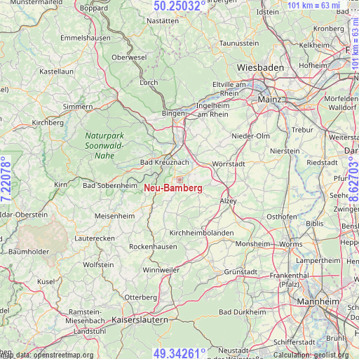
Neu-Bamberg GPS coordinates[2]
49° 47' 54.924" North, 7° 55' 26.04" East
| Map corner | latitude | longitude |
|---|---|---|
| Upper-left | 50.25032°, | 7.22078° |
| Center: | 49.79859°, | 7.9239° |
| Lower-right: | 49.34261°, | 8.62703° |
| Map W x H: | 100.9×100.9 km | = 62.7×62.7mi |
| max Lat: | 55.01917° ⇑69.1% North |
| Neu-Bamberg: | 49.79859° |
| min Lat: | ⇓30.9% South 47.40724° |
| min Long | Neu-Bamberg | max Long |
| 5.92978° | 7.9239° | 14.98853° |
| W 21.5%⇐ | ⇒78.5% E |
Elevation
Elevation of Neu-Bamberg is 175 m = 574 ft, and this is 74.1 m = 243 ft below average elevation for this country.
| Max E: |
1256 m = 4121 ft | 57% |
| Avg. | 249.1 m = 817 ft | |
| Neu-Bamberg | 175 m = 574 ft | |
Min E: |
-5 m = -16 ft | 43% |
See also: Germany elevation on elevation.city.
Geographical zone
Neu-Bamberg is located in North temperate zone (between Tropic of Cancer and the Arctic Circle). Distance of this North polar circle is 1864.1 km =1158.3 mi to North.| Distance of | km | miles | from Neu-Bamberg |
|---|---|---|---|
| North Pole | 4470 | 2777.5 | to North |
| Arctic Circle | 1864.1 | 1158.3 | to North |
| Tropic Cancer | 2931.2 | 1821.4 | to South |
| Equator | 5537.1 | 3440.6 | to South |


Nearby cities:
15 places around Neu-Bamberg: (largest is in red/bold)
• Badenheim
4.9 km =3 mi,  38°
38°
• Eckelsheim
4.3 km =2.7 mi,  87°
87°
• Frei-Laubersheim
1.7 km =1.1 mi,  275°
275°
• Fürfeld
3.3 km =2.1 mi,  223°
223°
• Gumbsheim
4.7 km =2.9 mi,  64°
64°
• Hackenheim
3.5 km =2.2 mi,  328°
328°
• Mörsfeld
5.4 km =3.4 mi,  172°
172°
• Niederhausen an der Appel
5.7 km =3.5 mi,  197°
197°
• Pleitersheim
4.3 km =2.7 mi,  25°
25°
• Siefersheim
1.9 km =1.2 mi, 85°
• Stein-Bockenheim
4.7 km =2.9 mi,  139°
139°
• Tiefenthal
5.7 km =3.5 mi, 197°
• Volxheim
2.1 km =1.3 mi,  18°
18°
• Wonsheim
3.5 km =2.2 mi,  118°
118°
• Wöllstein
3.7 km =2.3 mi, 56°
Sources, notices
• [Note1] Compared only with cities in Germany existing in our database
• [Src1] Map data: © OpenStreetMap contributors (CC-BY-SA)
• [Src2] Other city data from geonames.org with taken over terms of usage.
• [Src3] Geographical zone / Annual Mean Temperature by Robert A. Rohde @ Wikipedia
