Fürfeld geodata
Fürfeld (Rheinland-Pfalz) is a seat of a fourth-order administrative division; located in Germany in Europe/Berlin (GMT+2) time zone. With population of 1,553 people, there are 5776 cities with bigger population in this country. Compared to other cities in Germany, 69.5% of cities are located further ↑North; 79.1% of cities are located further →East and 50.9% of cities have higher elevation than Fürfeld. Note1
Administrative division(s):
- Level 1: Rheinland-Pfalz
- Level 3: Landkreis Bad Kreuznach
- Level 4: Fürfeld


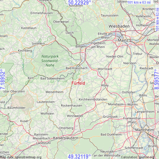
Fürfeld GPS coordinates[2]
49° 46' 38.532" North, 7° 53' 33.504" East
| Map corner | latitude | longitude |
|---|---|---|
| Upper-left | 50.22929°, | 7.18952° |
| Center: | 49.77737°, | 7.89264° |
| Lower-right: | 49.32119°, | 8.59577° |
| Map W x H: | 101×101 km | = 62.8×62.8mi |
| max Lat: | 55.01917° ⇑69.5% North |
| Fürfeld: | 49.77737° |
| min Lat: | ⇓30.5% South 47.40724° |
| min Long | Fürfeld | max Long |
| 5.92978° | 7.89264° | 14.98853° |
| W 20.9%⇐ | ⇒79.1% E |
Elevation
Elevation of Fürfeld is 219 m = 719 ft, and this is 30.1 m = 99 ft below average elevation for this country.
| Max E: |
1256 m = 4121 ft | 50.9% |
| Avg. | 249.1 m = 817 ft | |
| Fürfeld | 219 m = 719 ft | |
Min E: |
-5 m = -16 ft | 49.1% |
See also: Germany elevation on elevation.city.
Geographical zone
Fürfeld is located in North temperate zone (between Tropic of Cancer and the Arctic Circle). Distance of this North polar circle is 1866.4 km =1159.7 mi to North.| Distance of | km | miles | from Fürfeld |
|---|---|---|---|
| North Pole | 4472.3 | 2779 | to North |
| Arctic Circle | 1866.4 | 1159.7 | to North |
| Tropic Cancer | 2928.8 | 1819.9 | to South |
| Equator | 5534.7 | 3439.1 | to South |


Nearby cities:
15 places around Fürfeld: (largest is in red/bold)
• Altenbamberg
4.3 km =2.7 mi,  278°
278°
• Bad Münster am Stein-Ebernburg
5.1 km =3.2 mi,  318°
318°
• Frei-Laubersheim
2.6 km =1.6 mi,  11°
11°
• Hackenheim
5.3 km =3.3 mi,  4°
4°
• Hochstätten
4.4 km =2.7 mi,  254°
254°
• Mörsfeld
4.2 km =2.6 mi,  136°
136°
• Münsterappel
4.9 km =3 mi,  187°
187°
• Neu-Bamberg
3.3 km =2.1 mi,  43°
43°
• Niederhausen an der Appel
3.1 km =1.9 mi,  170°
170°
• Siefersheim
4.8 km =3 mi,  58°
58°
• Stein-Bockenheim
5.4 km =3.4 mi,  102°
102°
• Tiefenthal
3.1 km =1.9 mi, 170°
• Volxheim
5.3 km =3.3 mi,  33°
33°
• Winterborn
3.6 km =2.2 mi,  211°
211°
• Wonsheim
5.4 km =3.4 mi,  82°
82°
Sources, notices
• [Note1] Compared only with cities in Germany existing in our database
• [Src1] Map data: © OpenStreetMap contributors (CC-BY-SA)
• [Src2] Other city data from geonames.org with taken over terms of usage.
• [Src3] Geographical zone / Annual Mean Temperature by Robert A. Rohde @ Wikipedia
