Nazza geodata
Nazza (Thuringia) is a seat of a fourth-order administrative division; located in Germany in Europe/Berlin (GMT+2) time zone. With population of 674 people, there are 8455 cities with bigger population in this country. Compared to other cities in Germany, 60.1% of cities are located further ↓South; 56.1% of cities are located further ←West and 51.9% of cities have lower elevation than Nazza. Note1


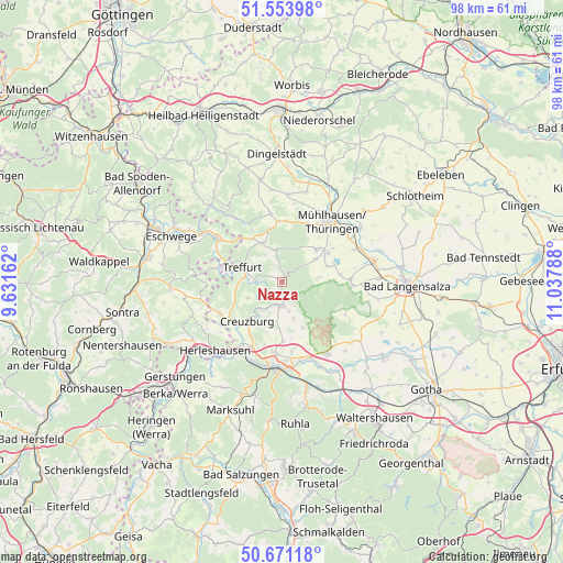
Nazza GPS coordinates[2]
51° 6' 52.884" North, 10° 20' 5.1" East
| Map corner | latitude | longitude |
|---|---|---|
| Upper-left | 51.55398°, | 9.63162° |
| Center: | 51.11469°, | 10.33475° |
| Lower-right: | 50.67118°, | 11.03788° |
| Map W x H: | 98.2×98.2 km | = 61×61mi |
| max Lat: | 55.01917° ⇑39.9% North |
| Nazza: | 51.11469° |
| min Lat: | ⇓60.1% South 47.40724° |
| min Long | Nazza | max Long |
| 5.92978° | 10.33475° | 14.98853° |
| W 56.1%⇐ | ⇒43.9% E |
Elevation
Elevation of Nazza is 239 m = 784 ft, and this is 10.1 m = 33 ft below average elevation for this country.
| Max E: |
1256 m = 4121 ft | 48.1% |
| Avg. | 249.1 m = 817 ft | |
| Nazza | 239 m = 784 ft | |
Min E: |
-5 m = -16 ft | 51.9% |
See also: Germany elevation on elevation.city.
Geographical zone
Nazza is located in North temperate zone (between Tropic of Cancer and the Arctic Circle). Distance of this North polar circle is 1717.8 km =1067.4 mi to North.| Distance of | km | miles | from Nazza |
|---|---|---|---|
| North Pole | 4323.6 | 2686.6 | to North |
| Arctic Circle | 1717.8 | 1067.4 | to North |
| Tropic Cancer | 3077.5 | 1912.3 | to South |
| Equator | 5683.4 | 3531.5 | to South |


Nearby cities:
15 places around Nazza: (largest is in red/bold)
• Bischofroda
6.8 km =4.2 mi,  162°
162°
• Creuzburg
9.2 km =5.7 mi,  221°
221°
• Ebenshausen
4.2 km =2.6 mi,  214°
214°
• Frankenroda
3.9 km =2.4 mi,  245°
245°
• Hallungen
2.1 km =1.3 mi,  357°
357°
• Heyerode
5.6 km =3.5 mi,  349°
349°
• Kammerforst
6.2 km =3.9 mi,  82°
82°
• Katharinenberg
9 km =5.6 mi,  325°
325°
• Langula
6.9 km =4.3 mi,  55°
55°
• Lauterbach
5.4 km =3.4 mi,  168°
168°
• Mihla
4.3 km =2.7 mi,  182°
182°
• Niederdorla
9.4 km =5.8 mi, 57°
• Oberdorla
8.3 km =5.2 mi,  46°
46°
• Oppershausen
8.3 km =5.2 mi, 75°
• Treffurt
7.5 km =4.7 mi,  289°
289°
Sources, notices
• [Note1] Compared only with cities in Germany existing in our database
• [Src1] Map data: © OpenStreetMap contributors (CC-BY-SA)
• [Src2] Other city data from geonames.org with taken over terms of usage.
• [Src3] Geographical zone / Annual Mean Temperature by Robert A. Rohde @ Wikipedia
