Creuzburg geodata
Creuzburg (Thuringia) is a populated place; located in Germany in Europe/Berlin (GMT+2) time zone. With population of 2,658 people, there are 4271 cities with bigger population in this country. Compared to other cities in Germany, 59.1% of cities are located further ↓South; 54.2% of cities are located further ←West and 53.1% of cities have higher elevation than Creuzburg. Note1


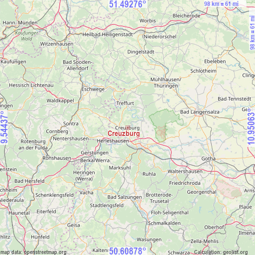
Creuzburg GPS coordinates[2]
51° 3' 10.368" North, 10° 14' 51" East
| Map corner | latitude | longitude |
|---|---|---|
| Upper-left | 51.49276°, | 9.54437° |
| Center: | 51.05288°, | 10.2475° |
| Lower-right: | 50.60878°, | 10.95063° |
| Map W x H: | 98.3×98.3 km | = 61.1×61.1mi |
| max Lat: | 55.01917° ⇑40.9% North |
| Creuzburg: | 51.05288° |
| min Lat: | ⇓59.1% South 47.40724° |
| min Long | Creuzburg | max Long |
| 5.92978° | 10.2475° | 14.98853° |
| W 54.2%⇐ | ⇒45.8% E |
Elevation
Elevation of Creuzburg is 203 m = 666 ft, and this is 46.1 m = 151 ft below average elevation for this country.
| Max E: |
1256 m = 4121 ft | 53.1% |
| Avg. | 249.1 m = 817 ft | |
| Creuzburg | 203 m = 666 ft | |
Min E: |
-5 m = -16 ft | 46.9% |
See also: Germany elevation on elevation.city.
Geographical zone
Creuzburg is located in North temperate zone (between Tropic of Cancer and the Arctic Circle). Distance of this North polar circle is 1724.6 km =1071.6 mi to North.| Distance of | km | miles | from Creuzburg |
|---|---|---|---|
| North Pole | 4330.5 | 2690.8 | to North |
| Arctic Circle | 1724.6 | 1071.6 | to North |
| Tropic Cancer | 3070.6 | 1908 | to South |
| Equator | 5676.5 | 3527.2 | to South |


Nearby cities:
15 places around Creuzburg: (largest is in red/bold)
• Bischofroda
8.1 km =5 mi,  87°
87°
• Ebenshausen
5 km =3.1 mi,  47°
47°
• Eisenach
9.3 km =5.8 mi,  149°
149°
• Frankenroda
5.8 km =3.6 mi,  25°
25°
• Hallungen
10.8 km =6.7 mi, 33°
• Herleshausen
7.6 km =4.7 mi,  227°
227°
• Ifta
4.7 km =2.9 mi,  288°
288°
• Krauthausen
4.2 km =2.6 mi,  161°
161°
• Lauchröden
9.1 km =5.7 mi,  223°
223°
• Lauterbach
7.3 km =4.5 mi,  77°
77°
• Mihla
6.4 km =4 mi,  66°
66°
• Nazza
9.2 km =5.7 mi,  41°
41°
• Treffurt
9.4 km =5.8 mi,  354°
354°
• Unterellen
11.4 km =7.1 mi,  212°
212°
• Weißenborn
12.2 km =7.6 mi,  311°
311°
Sources, notices
• [Note1] Compared only with cities in Germany existing in our database
• [Src1] Map data: © OpenStreetMap contributors (CC-BY-SA)
• [Src2] Other city data from geonames.org with taken over terms of usage.
• [Src3] Geographical zone / Annual Mean Temperature by Robert A. Rohde @ Wikipedia
