Heyerode geodata
Heyerode (Thuringia) is a populated place; located in Germany in Europe/Berlin (GMT+2) time zone. With population of 2,437 people, there are 4516 cities with bigger population in this country. Compared to other cities in Germany, 61% of cities are located further ↓South; 55.8% of cities are located further ←West and 68.7% of cities have lower elevation than Heyerode. Note1


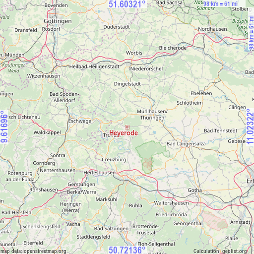
Heyerode GPS coordinates[2]
51° 9' 51.804" North, 10° 19' 12.324" East
| Map corner | latitude | longitude |
|---|---|---|
| Upper-left | 51.60321°, | 9.61696° |
| Center: | 51.16439°, | 10.32009° |
| Lower-right: | 50.72136°, | 11.02322° |
| Map W x H: | 98.1×98.1 km | = 61×61mi |
| max Lat: | 55.01917° ⇑39% North |
| Heyerode: | 51.16439° |
| min Lat: | ⇓61% South 47.40724° |
| min Long | Heyerode | max Long |
| 5.92978° | 10.32009° | 14.98853° |
| W 55.8%⇐ | ⇒44.2% E |
Elevation
Elevation of Heyerode is 348 m = 1142 ft, and this is 98.9 m = 324 ft above average elevation for this country.
| Max E: |
1256 m = 4121 ft | 31.3% |
| Heyerode | 348 m 1142 ft | |
| Avg. | 249.1 m = 817 ft | |
Min E: |
-5 m = -16 ft | 68.7% |
See also: Germany elevation on elevation.city.
Geographical zone
Heyerode is located in North temperate zone (between Tropic of Cancer and the Arctic Circle). Distance of this North polar circle is 1712.2 km =1063.9 mi to North.| Distance of | km | miles | from Heyerode |
|---|---|---|---|
| North Pole | 4318.1 | 2683.1 | to North |
| Arctic Circle | 1712.2 | 1063.9 | to North |
| Tropic Cancer | 3083 | 1915.7 | to South |
| Equator | 5688.9 | 3534.9 | to South |


Nearby cities:
15 places around Heyerode: (largest is in red/bold)
• Ebenshausen
9.1 km =5.7 mi,  188°
188°
• Effelder
9.8 km =6.1 mi,  328°
328°
• Frankenroda
7.6 km =4.7 mi,  199°
199°
• Hallungen
3.6 km =2.2 mi,  165°
165°
• Kammerforst
8.6 km =5.3 mi,  123°
123°
• Katharinenberg
4.5 km =2.8 mi,  294°
294°
• Langula
6.9 km =4.3 mi,  103°
103°
• Mihla
9.8 km =6.1 mi,  175°
175°
• Mühlhausen
10.5 km =6.5 mi,  61°
61°
• Nazza
5.6 km =3.5 mi, 169°
• Niederdorla
8.9 km =5.5 mi,  92°
92°
• Oberdorla
7.1 km =4.4 mi, 88°
• Oppershausen
9.7 km =6 mi,  110°
110°
• Treffurt
6.8 km =4.2 mi,  243°
243°
• Wanfried
10.5 km =6.5 mi,  280°
280°
Sources, notices
• [Note1] Compared only with cities in Germany existing in our database
• [Src1] Map data: © OpenStreetMap contributors (CC-BY-SA)
• [Src2] Other city data from geonames.org with taken over terms of usage.
• [Src3] Geographical zone / Annual Mean Temperature by Robert A. Rohde @ Wikipedia
