Nauendorf geodata
Nauendorf (Saxony-Anhalt) is a populated place; located in Germany in Europe/Berlin (GMT+2) time zone. With population of 1,832 people, there are 5297 cities with bigger population in this country. Compared to other cities in Germany, 67.7% of cities are located further ↓South; 80.1% of cities are located further ←West and 61.3% of cities have higher elevation than Nauendorf. Note1


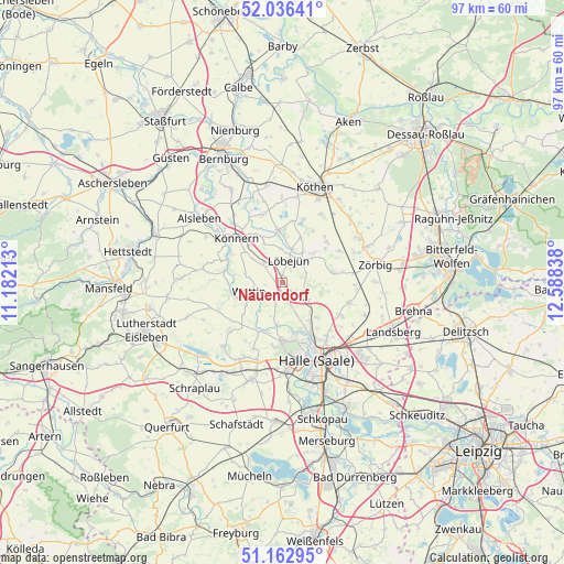
Nauendorf GPS coordinates[2]
51° 36' 6.408" North, 11° 53' 6.9" East
| Map corner | latitude | longitude |
|---|---|---|
| Upper-left | 52.03641°, | 11.18213° |
| Center: | 51.60178°, | 11.88525° |
| Lower-right: | 51.16295°, | 12.58838° |
| Map W x H: | 97.1×97.1 km | = 60.3×60.3mi |
| max Lat: | 55.01917° ⇑32.3% North |
| Nauendorf: | 51.60178° |
| min Lat: | ⇓67.7% South 47.40724° |
| min Long | Nauendorf | max Long |
| 5.92978° | 11.88525° | 14.98853° |
| W 80.1%⇐ | ⇒19.9% E |
Elevation
Elevation of Nauendorf is 144 m = 472 ft, and this is 105.1 m = 345 ft below average elevation for this country.
| Max E: |
1256 m = 4121 ft | 61.3% |
| Avg. | 249.1 m = 817 ft | |
| Nauendorf | 144 m = 472 ft | |
Min E: |
-5 m = -16 ft | 38.7% |
See also: Germany elevation on elevation.city.
Geographical zone
Nauendorf is located in North temperate zone (between Tropic of Cancer and the Arctic Circle). Distance of this North polar circle is 1663.6 km =1033.7 mi to North.| Distance of | km | miles | from Nauendorf |
|---|---|---|---|
| North Pole | 4269.5 | 2652.9 | to North |
| Arctic Circle | 1663.6 | 1033.7 | to North |
| Tropic Cancer | 3131.7 | 1945.9 | to South |
| Equator | 5737.6 | 3565.2 | to South |


Nearby cities:
15 places around Nauendorf: (largest is in red/bold)
• Brachwitz
7.3 km =4.5 mi,  188°
188°
• Domnitz
4.6 km =2.9 mi,  315°
315°
• Edlau
8.6 km =5.3 mi,  326°
326°
• Gutenberg
8.5 km =5.3 mi,  135°
135°
• Krosigk
3.5 km =2.2 mi,  75°
75°
• Löbejün
3.9 km =2.4 mi,  16°
16°
• Morl
6 km =3.7 mi,  155°
155°
• Neutz-Lettewitz
3.1 km =1.9 mi,  277°
277°
• Petersberg
4.7 km =2.9 mi,  97°
97°
• Plötz
6 km =3.7 mi,  47°
47°
• Sennewitz
8 km =5 mi, 144°
• Teicha
6.8 km =4.2 mi,  134°
134°
• Trebitz
2.9 km =1.8 mi, 126°
• Wallwitz
3.8 km =2.4 mi, 128°
• Wettin
5.7 km =3.5 mi,  252°
252°
Sources, notices
• [Note1] Compared only with cities in Germany existing in our database
• [Src1] Map data: © OpenStreetMap contributors (CC-BY-SA)
• [Src2] Other city data from geonames.org with taken over terms of usage.
• [Src3] Geographical zone / Annual Mean Temperature by Robert A. Rohde @ Wikipedia
