Brachwitz geodata
Brachwitz (Saxony-Anhalt) is a populated place; located in Germany in Europe/Berlin (GMT+2) time zone. With population of 991 people, there are 7219 cities with bigger population in this country. Compared to other cities in Germany, 66.8% of cities are located further ↓South; 79.9% of cities are located further ←West and 71.7% of cities have higher elevation than Brachwitz. Note1


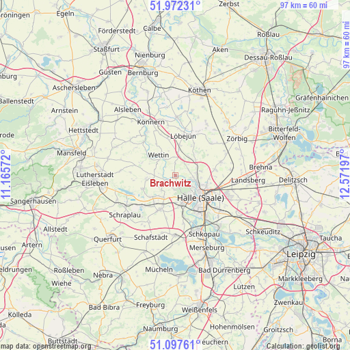
Brachwitz GPS coordinates[2]
51° 32' 13.416" North, 11° 52' 7.824" East
| Map corner | latitude | longitude |
|---|---|---|
| Upper-left | 51.97231°, | 11.16572° |
| Center: | 51.53706°, | 11.86884° |
| Lower-right: | 51.09761°, | 12.57197° |
| Map W x H: | 97.3×97.3 km | = 60.5×60.5mi |
| max Lat: | 55.01917° ⇑33.2% North |
| Brachwitz: | 51.53706° |
| min Lat: | ⇓66.8% South 47.40724° |
| min Long | Brachwitz | max Long |
| 5.92978° | 11.86884° | 14.98853° |
| W 79.9%⇐ | ⇒20.1% E |
Elevation
Elevation of Brachwitz is 80 m = 262 ft, and this is 169.1 m = 555 ft below average elevation for this country.
| Max E: |
1256 m = 4121 ft | 71.7% |
| Avg. | 249.1 m = 817 ft | |
| Brachwitz | 80 m = 262 ft | |
Min E: |
-5 m = -16 ft | 28.3% |
See also: Germany elevation on elevation.city.
Geographical zone
Brachwitz is located in North temperate zone (between Tropic of Cancer and the Arctic Circle). Distance of this North polar circle is 1670.8 km =1038.2 mi to North.| Distance of | km | miles | from Brachwitz |
|---|---|---|---|
| North Pole | 4276.7 | 2657.4 | to North |
| Arctic Circle | 1670.8 | 1038.2 | to North |
| Tropic Cancer | 3124.5 | 1941.5 | to South |
| Equator | 5730.4 | 3560.7 | to South |


Nearby cities:
15 places around Brachwitz: (largest is in red/bold)
• Bennstedt
6.8 km =4.2 mi,  205°
205°
• Gutenberg
7.2 km =4.5 mi,  81°
81°
• Halle Neustadt
7.2 km =4.5 mi,  153°
153°
• Lieskau
3.7 km =2.3 mi,  187°
187°
• Morl
4 km =2.5 mi,  64°
64°
• Nauendorf
7.3 km =4.5 mi,  8°
8°
• Salzmünde
3.2 km =2 mi,  248°
248°
• Schochwitz
7.9 km =4.9 mi,  265°
265°
• Sennewitz
5.8 km =3.6 mi, 83°
• Teicha
6.4 km =4 mi,  67°
67°
• Trebitz
6.5 km =4 mi,  32°
32°
• Wallwitz
6.4 km =4 mi,  40°
40°
• Wettin
7 km =4.3 mi,  321°
321°
• Zappendorf
5.9 km =3.7 mi,  239°
239°
• Zscherben
7.8 km =4.8 mi,  179°
179°
Sources, notices
• [Note1] Compared only with cities in Germany existing in our database
• [Src1] Map data: © OpenStreetMap contributors (CC-BY-SA)
• [Src2] Other city data from geonames.org with taken over terms of usage.
• [Src3] Geographical zone / Annual Mean Temperature by Robert A. Rohde @ Wikipedia
