Nachterstedt geodata
Nachterstedt (Saxony-Anhalt) is a populated place; located in Germany in Europe/Berlin (GMT+2) time zone. With population of 2,232 people, there are 4772 cities with bigger population in this country. Compared to other cities in Germany, 70% of cities are located further ↓South; 71.8% of cities are located further ←West and 63.5% of cities have higher elevation than Nachterstedt. Note1


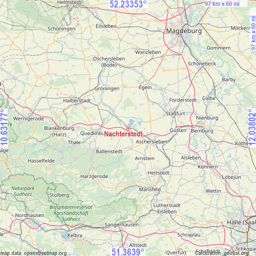
Nachterstedt GPS coordinates[2]
51° 48' 2.916" North, 11° 20' 5.604" East
| Map corner | latitude | longitude |
|---|---|---|
| Upper-left | 52.23353°, | 10.63177° |
| Center: | 51.80081°, | 11.33489° |
| Lower-right: | 51.3639°, | 12.03802° |
| Map W x H: | 96.7×96.7 km | = 60.1×60.1mi |
| max Lat: | 55.01917° ⇑30% North |
| Nachterstedt: | 51.80081° |
| min Lat: | ⇓70% South 47.40724° |
| min Long | Nachterstedt | max Long |
| 5.92978° | 11.33489° | 14.98853° |
| W 71.8%⇐ | ⇒28.2% E |
Elevation
Elevation of Nachterstedt is 129 m = 423 ft, and this is 120.1 m = 394 ft below average elevation for this country.
| Max E: |
1256 m = 4121 ft | 63.5% |
| Avg. | 249.1 m = 817 ft | |
| Nachterstedt | 129 m = 423 ft | |
Min E: |
-5 m = -16 ft | 36.5% |
See also: Germany elevation on elevation.city.
Geographical zone
Nachterstedt is located in North temperate zone (between Tropic of Cancer and the Arctic Circle). Distance of this North polar circle is 1641.5 km =1020 mi to North.| Distance of | km | miles | from Nachterstedt |
|---|---|---|---|
| North Pole | 4247.4 | 2639.2 | to North |
| Arctic Circle | 1641.5 | 1020 | to North |
| Tropic Cancer | 3153.8 | 1959.7 | to South |
| Equator | 5759.7 | 3578.9 | to South |


Nearby cities:
15 places around Nachterstedt: (largest is in red/bold)
• Aschersleben
9.9 km =6.2 mi,  119°
119°
• Ballenstedt
11.5 km =7.1 mi,  217°
217°
• Cochstedt
10.5 km =6.5 mi,  29°
29°
• Ditfurt
10 km =6.2 mi,  291°
291°
• Frose
3.1 km =1.9 mi,  100°
100°
• Gatersleben
4.1 km =2.5 mi,  305°
305°
• Hausneindorf
6.1 km =3.8 mi,  315°
315°
• Hedersleben
8.7 km =5.4 mi, 318°
• Hoym
2.5 km =1.6 mi, 217°
• Schadeleben
4.4 km =2.7 mi,  23°
23°
• Wedderstedt
7.6 km =4.7 mi,  304°
304°
• Welbsleben
12.1 km =7.5 mi,  149°
149°
• Westdorf
10 km =6.2 mi,  136°
136°
• Wilsleben
6.2 km =3.9 mi,  91°
91°
• Winningen
8.3 km =5.2 mi,  72°
72°
Sources, notices
• [Note1] Compared only with cities in Germany existing in our database
• [Src1] Map data: © OpenStreetMap contributors (CC-BY-SA)
• [Src2] Other city data from geonames.org with taken over terms of usage.
• [Src3] Geographical zone / Annual Mean Temperature by Robert A. Rohde @ Wikipedia
