Hoym geodata
Hoym (Saxony-Anhalt) is a populated place; located in Germany in Europe/Berlin (GMT+2) time zone. With population of 2,680 people, there are 4249 cities with bigger population in this country. Compared to other cities in Germany, 69.7% of cities are located further ↓South; 71.5% of cities are located further ←West and 63.3% of cities have higher elevation than Hoym. Note1


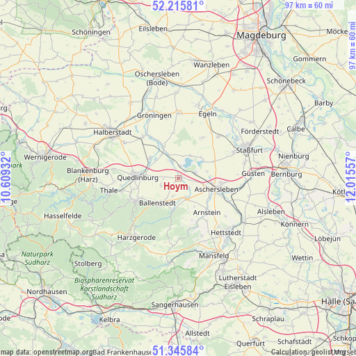
Hoym GPS coordinates[2]
51° 46' 58.512" North, 11° 18' 44.784" East
| Map corner | latitude | longitude |
|---|---|---|
| Upper-left | 52.21581°, | 10.60932° |
| Center: | 51.78292°, | 11.31244° |
| Lower-right: | 51.34584°, | 12.01557° |
| Map W x H: | 96.7×96.7 km | = 60.1×60.1mi |
| max Lat: | 55.01917° ⇑30.3% North |
| Hoym: | 51.78292° |
| min Lat: | ⇓69.7% South 47.40724° |
| min Long | Hoym | max Long |
| 5.92978° | 11.31244° | 14.98853° |
| W 71.5%⇐ | ⇒28.5% E |
Elevation
Elevation of Hoym is 130 m = 427 ft, and this is 119.1 m = 391 ft below average elevation for this country.
| Max E: |
1256 m = 4121 ft | 63.3% |
| Avg. | 249.1 m = 817 ft | |
| Hoym | 130 m = 427 ft | |
Min E: |
-5 m = -16 ft | 36.7% |
See also: Germany elevation on elevation.city.
Geographical zone
Hoym is located in North temperate zone (between Tropic of Cancer and the Arctic Circle). Distance of this North polar circle is 1643.5 km =1021.2 mi to North.| Distance of | km | miles | from Hoym |
|---|---|---|---|
| North Pole | 4249.3 | 2640.4 | to North |
| Arctic Circle | 1643.5 | 1021.2 | to North |
| Tropic Cancer | 3151.8 | 1958.4 | to South |
| Equator | 5757.7 | 3577.7 | to South |


Nearby cities:
15 places around Hoym: (largest is in red/bold)
• Aschersleben
10.6 km =6.6 mi,  105°
105°
• Ballenstedt
9 km =5.6 mi,  217°
217°
• Ditfurt
9.5 km =5.9 mi,  305°
305°
• Frose
4.8 km =3 mi,  72°
72°
• Gatersleben
4.7 km =2.9 mi,  337°
337°
• Hausneindorf
6.9 km =4.3 mi, 336°
• Hedersleben
9.5 km =5.9 mi,  333°
333°
• Nachterstedt
2.5 km =1.6 mi,  37°
37°
• Quedlinburg
11.2 km =7 mi,  273°
273°
• Schadeleben
6.9 km =4.3 mi,  28°
28°
• Wedderstedt
7.9 km =4.9 mi,  323°
323°
• Welbsleben
11.4 km =7.1 mi,  137°
137°
• Westdorf
9.9 km =6.2 mi,  121°
121°
• Wilsleben
8 km =5 mi,  76°
76°
• Winningen
10.5 km =6.5 mi,  64°
64°
Sources, notices
• [Note1] Compared only with cities in Germany existing in our database
• [Src1] Map data: © OpenStreetMap contributors (CC-BY-SA)
• [Src2] Other city data from geonames.org with taken over terms of usage.
• [Src3] Geographical zone / Annual Mean Temperature by Robert A. Rohde @ Wikipedia
