Mönchenholzhausen geodata
Mönchenholzhausen (Thuringia) is a seat of a fourth-order administrative division; located in Germany in Europe/Berlin (GMT+2) time zone. With population of 1,652 people, there are 5599 cities with bigger population in this country. Compared to other cities in Germany, 57.5% of cities are located further ↓South; 69.1% of cities are located further ←West and 56.7% of cities have lower elevation than Mönchenholzhausen. Note1


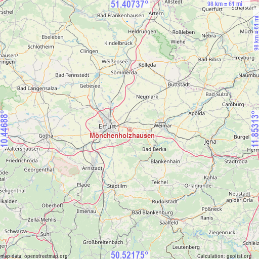
Mönchenholzhausen GPS coordinates[2]
50° 58' 0.012" North, 11° 9' 0" East
| Map corner | latitude | longitude |
|---|---|---|
| Upper-left | 51.40737°, | 10.44688° |
| Center: | 50.96667°, | 11.15° |
| Lower-right: | 50.52175°, | 11.85313° |
| Map W x H: | 98.5×98.5 km | = 61.2×61.2mi |
| max Lat: | 55.01917° ⇑42.5% North |
| Mönchenholzhausen: | 50.96667° |
| min Lat: | ⇓57.5% South 47.40724° |
| min Long | Mönchenholzhau | max Long |
| 5.92978° | 11.15° | 14.98853° |
| W 69.1%⇐ | ⇒30.9% E |
Elevation
Elevation of Mönchenholzhausen is 270 m = 886 ft, and this is 20.9 m = 69 ft above average elevation for this country.
| Max E: |
1256 m = 4121 ft | 43.3% |
| Mönchenholzhausen | 270 m 886 ft | |
| Avg. | 249.1 m = 817 ft | |
Min E: |
-5 m = -16 ft | 56.7% |
See also: Germany elevation on elevation.city.
Geographical zone
Mönchenholzhausen is located in North temperate zone (between Tropic of Cancer and the Arctic Circle). Distance of this North polar circle is 1734.2 km =1077.6 mi to North.| Distance of | km | miles | from Mönchenholzhausen |
|---|---|---|---|
| North Pole | 4340.1 | 2696.8 | to North |
| Arctic Circle | 1734.2 | 1077.6 | to North |
| Tropic Cancer | 3061 | 1902 | to South |
| Equator | 5667 | 3521.3 | to South |


Nearby cities:
15 places around Mönchenholzhausen: (largest is in red/bold)
• Bechstedtstraß
4 km =2.5 mi,  117°
117°
• Erfurt
8.3 km =5.2 mi,  279°
279°
• Großmölsen
7.5 km =4.7 mi,  351°
351°
• Hohenfelden
9.8 km =6.1 mi,  175°
175°
• Hopfgarten
5.6 km =3.5 mi,  66°
66°
• Isseroda
5 km =3.1 mi,  102°
102°
• Kleinmölsen
7.8 km =4.8 mi,  342°
342°
• Klettbach
5.6 km =3.5 mi, 180°
• Nauendorf
8.3 km =5.2 mi,  164°
164°
• Niederzimmern
5.1 km =3.2 mi,  33°
33°
• Nohra
7.7 km =4.8 mi,  94°
94°
• Ollendorf
7.8 km =4.8 mi,  17°
17°
• Tonndorf
9.4 km =5.8 mi, 156°
• Troistedt
7.9 km =4.9 mi, 117°
• Udestedt
9.3 km =5.8 mi, 352°
Sources, notices
• [Note1] Compared only with cities in Germany existing in our database
• [Src1] Map data: © OpenStreetMap contributors (CC-BY-SA)
• [Src2] Other city data from geonames.org with taken over terms of usage.
• [Src3] Geographical zone / Annual Mean Temperature by Robert A. Rohde @ Wikipedia
