Nohra geodata
Nohra (Thuringia) is a seat of a fourth-order administrative division; located in Germany in Europe/Berlin (GMT+2) time zone. With population of 1,430 people, there are 6021 cities with bigger population in this country. Compared to other cities in Germany, 57.4% of cities are located further ↓South; 70.8% of cities are located further ←West and 64.5% of cities have lower elevation than Nohra. Note1


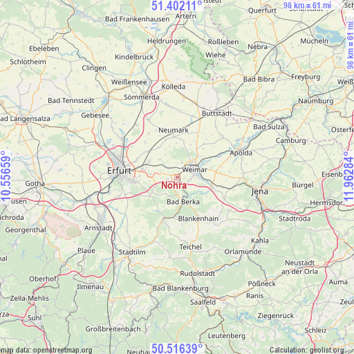
Nohra GPS coordinates[2]
50° 57' 40.896" North, 11° 15' 34.956" East
| Map corner | latitude | longitude |
|---|---|---|
| Upper-left | 51.40211°, | 10.55659° |
| Center: | 50.96136°, | 11.25971° |
| Lower-right: | 50.51639°, | 11.96284° |
| Map W x H: | 98.5×98.5 km | = 61.2×61.2mi |
| max Lat: | 55.01917° ⇑42.6% North |
| Nohra: | 50.96136° |
| min Lat: | ⇓57.4% South 47.40724° |
| min Long | Nohra | max Long |
| 5.92978° | 11.25971° | 14.98853° |
| W 70.8%⇐ | ⇒29.2% E |
Elevation
Elevation of Nohra is 318 m = 1043 ft, and this is 68.9 m = 226 ft above average elevation for this country.
| Max E: |
1256 m = 4121 ft | 35.5% |
| Nohra | 318 m 1043 ft | |
| Avg. | 249.1 m = 817 ft | |
Min E: |
-5 m = -16 ft | 64.5% |
See also: Germany elevation on elevation.city.
Geographical zone
Nohra is located in North temperate zone (between Tropic of Cancer and the Arctic Circle). Distance of this North polar circle is 1734.8 km =1078 mi to North.| Distance of | km | miles | from Nohra |
|---|---|---|---|
| North Pole | 4340.7 | 2697.2 | to North |
| Arctic Circle | 1734.8 | 1078 | to North |
| Tropic Cancer | 3060.5 | 1901.7 | to South |
| Equator | 5666.4 | 3520.9 | to South |


Nearby cities:
15 places around Nohra: (largest is in red/bold)
• Bad Berka
7 km =4.3 mi,  166°
166°
• Bechstedtstraß
4.4 km =2.7 mi,  253°
253°
• Buchfart
6.8 km =4.2 mi,  131°
131°
• Ettersburg
8.2 km =5.1 mi,  9°
9°
• Hetschburg
6.1 km =3.8 mi,  152°
152°
• Hopfgarten
3.8 km =2.4 mi,  317°
317°
• Isseroda
2.8 km =1.7 mi,  259°
259°
• Kleinobringen
8.9 km =5.5 mi,  26°
26°
• Kromsdorf
8.6 km =5.3 mi,  60°
60°
• Mönchenholzhausen
7.7 km =4.8 mi,  274°
274°
• Niederzimmern
6.8 km =4.2 mi,  314°
314°
• Oettern
8.1 km =5 mi,  122°
122°
• Troistedt
3.2 km =2 mi,  192°
192°
• Vollersroda
5.7 km =3.5 mi, 119°
• Weimar
5.3 km =3.3 mi,  66°
66°
Sources, notices
• [Note1] Compared only with cities in Germany existing in our database
• [Src1] Map data: © OpenStreetMap contributors (CC-BY-SA)
• [Src2] Other city data from geonames.org with taken over terms of usage.
• [Src3] Geographical zone / Annual Mean Temperature by Robert A. Rohde @ Wikipedia
