Erfurt geodata
Erfurt (Thuringia) is a seat of a first-order administrative division; located in Germany in Europe/Berlin (GMT+2) time zone. With population of 203,254 people, there are 44 cities with bigger population in this country. Compared to other cities in Germany, 57.8% of cities are located further ↓South; 67.4% of cities are located further ←West and 54.2% of cities have higher elevation than Erfurt. Note1


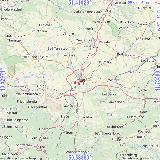
Erfurt GPS coordinates[2]
50° 58' 43.32" North, 11° 1' 58.188" East
| Map corner | latitude | longitude |
|---|---|---|
| Upper-left | 51.41929°, | 10.32971° |
| Center: | 50.9787°, | 11.03283° |
| Lower-right: | 50.53389°, | 11.73596° |
| Map W x H: | 98.4×98.4 km | = 61.1×61.1mi |
| max Lat: | 55.01917° ⇑42.2% North |
| Erfurt: | 50.9787° |
| min Lat: | ⇓57.8% South 47.40724° |
| min Long | Erfurt | max Long |
| 5.92978° | 11.03283° | 14.98853° |
| W 67.4%⇐ | ⇒32.6% E |
Elevation
Elevation of Erfurt is 195 m = 640 ft, and this is 54.1 m = 177 ft below average elevation for this country.
| Max E: |
1256 m = 4121 ft | 54.2% |
| Avg. | 249.1 m = 817 ft | |
| Erfurt | 195 m = 640 ft | |
Min E: |
-5 m = -16 ft | 45.8% |
See also: Erfurt elevation on elevation.city.
Geographical zone
Erfurt is located in North temperate zone (between Tropic of Cancer and the Arctic Circle). Distance of this North polar circle is 1732.9 km =1076.8 mi to North.| Distance of | km | miles | from Erfurt |
|---|---|---|---|
| North Pole | 4338.8 | 2696 | to North |
| Arctic Circle | 1732.9 | 1076.8 | to North |
| Tropic Cancer | 3062.4 | 1902.9 | to South |
| Equator | 5668.3 | 3522.1 | to South |


Nearby cities:
15 places around Erfurt: (largest is in red/bold)
• Elxleben
9.8 km =6.1 mi,  323°
323°
• Gamstädt
10.9 km =6.8 mi,  252°
252°
• Großmölsen
9.3 km =5.8 mi,  49°
49°
• Hochheim
3.2 km =2 mi,  227°
227°
• Ingersleben
9.3 km =5.8 mi, 226°
• Kirchheim
10.7 km =6.6 mi,  186°
186°
• Kleinmölsen
8.4 km =5.2 mi,  43°
43°
• Klettbach
10.7 km =6.6 mi,  130°
130°
• Mönchenholzhausen
8.3 km =5.2 mi,  99°
99°
• Neudietendorf
11.1 km =6.9 mi, 228°
• Niederzimmern
11.4 km =7.1 mi,  75°
75°
• Nöda
9.8 km =6.1 mi,  353°
353°
• Rockhausen
8.6 km =5.3 mi,  176°
176°
• Udestedt
10.6 km =6.6 mi, 41°
• Zimmernsupra
11.6 km =7.2 mi,  272°
272°
Sources, notices
• [Note1] Compared only with cities in Germany existing in our database
• [Src1] Map data: © OpenStreetMap contributors (CC-BY-SA)
• [Src2] Other city data from geonames.org with taken over terms of usage.
• [Src3] Geographical zone / Annual Mean Temperature by Robert A. Rohde @ Wikipedia
