Nebel geodata
Nebel (Schleswig-Holstein) is a seat of a fourth-order administrative division; located in Germany in Europe/Berlin (GMT+2) time zone. With population of 952 people, there are 7340 cities with bigger population in this country. Compared to other cities in Germany, 98.9% of cities are located further ↓South; 72.3% of cities are located further →East and 93.5% of cities have higher elevation than Nebel. Note1


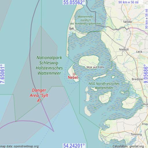
Nebel GPS coordinates[2]
54° 39' 3.06" North, 8° 21' 13.428" East
| Map corner | latitude | longitude |
|---|---|---|
| Upper-left | 55.05562°, | 7.65061° |
| Center: | 54.65085°, | 8.35373° |
| Lower-right: | 54.24201°, | 9.05686° |
| Map W x H: | 90.5×90.5 km | = 56.2×56.2mi |
| max Lat: | 55.01917° ⇑1.1% North |
| Nebel: | 54.65085° |
| min Lat: | ⇓98.9% South 47.40724° |
| min Long | Nebel | max Long |
| 5.92978° | 8.35373° | 14.98853° |
| W 27.7%⇐ | ⇒72.3% E |
Elevation
Elevation of Nebel is 12 m = 39 ft, and this is 237.1 m = 778 ft below average elevation for this country.
| Max E: |
1256 m = 4121 ft | 93.5% |
| Avg. | 249.1 m = 817 ft | |
| Nebel | 12 m = 39 ft | |
Min E: |
-5 m = -16 ft | 6.5% |
See also: Germany elevation on elevation.city.
Geographical zone
Nebel is located in North temperate zone (between Tropic of Cancer and the Arctic Circle). Distance of this North polar circle is 1324.6 km =823.1 mi to North.| Distance of | km | miles | from Nebel |
|---|---|---|---|
| North Pole | 3930.5 | 2442.3 | to North |
| Arctic Circle | 1324.6 | 823.1 | to North |
| Tropic Cancer | 3470.7 | 2156.6 | to South |
| Equator | 6076.6 | 3775.8 | to South |


Nearby cities:
15 places around Nebel: (largest is in red/bold)
• Alkersum
11.8 km =7.3 mi,  57°
57°
• Borgsum
8.7 km =5.4 mi,  50°
50°
• Dunsum
10 km =6.2 mi,  27°
27°
• Hörnum
12.6 km =7.8 mi,  340°
340°
• Midlum
12.9 km =8 mi, 56°
• Nieblum
9.9 km =6.2 mi, 62°
• Norddorf
3.5 km =2.2 mi, 337°
• Oevenum
13.2 km =8.2 mi, 60°
• Oldsum
10.7 km =6.6 mi, 33°
• Süderende
10 km =6.2 mi, 33°
• Utersum
7.8 km =4.8 mi, 25°
• Witsum
7.8 km =4.8 mi, 45°
• Wittdün
3.5 km =2.2 mi,  139°
139°
• Wrixum
13.7 km =8.5 mi,  66°
66°
• Wyk auf Föhr
14.4 km =8.9 mi, 71°
Sources, notices
• [Note1] Compared only with cities in Germany existing in our database
• [Src1] Map data: © OpenStreetMap contributors (CC-BY-SA)
• [Src2] Other city data from geonames.org with taken over terms of usage.
• [Src3] Geographical zone / Annual Mean Temperature by Robert A. Rohde @ Wikipedia
