Martinhagen geodata
Martinhagen (Hesse) is a populated place; located in Germany in Europe/Berlin (GMT+2) time zone. With population of 1,500 people, there are 5880 cities with bigger population in this country. Compared to other cities in Germany, 63% of cities are located further ↓South; 60.9% of cities are located further →East and 73.3% of cities have lower elevation than Martinhagen. Note1
Administrative division(s):
- Level 1: Hesse
- Level 2: Regierungsbezirk Kassel
- Level 3: Landkreis Kassel
- Level 4: Schauenburg


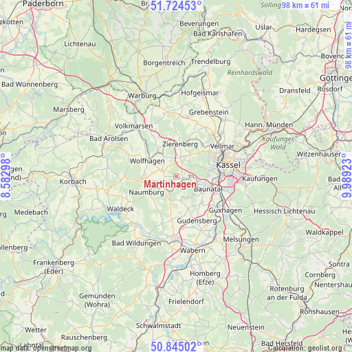
Martinhagen GPS coordinates[2]
51° 17' 12.768" North, 9° 17' 9.996" East
| Map corner | latitude | longitude |
|---|---|---|
| Upper-left | 51.72453°, | 8.58298° |
| Center: | 51.28688°, | 9.28611° |
| Lower-right: | 50.84502°, | 9.98923° |
| Map W x H: | 97.8×97.8 km | = 60.8×60.8mi |
| max Lat: | 55.01917° ⇑37% North |
| Martinhagen: | 51.28688° |
| min Lat: | ⇓63% South 47.40724° |
| min Long | Martinhagen | max Long |
| 5.92978° | 9.28611° | 14.98853° |
| W 39.1%⇐ | ⇒60.9% E |
Elevation
Elevation of Martinhagen is 385 m = 1263 ft, and this is 135.9 m = 446 ft above average elevation for this country.
| Max E: |
1256 m = 4121 ft | 26.7% |
| Martinhagen | 385 m 1263 ft | |
| Avg. | 249.1 m = 817 ft | |
Min E: |
-5 m = -16 ft | 73.3% |
See also: Germany elevation on elevation.city.
Geographical zone
Martinhagen is located in North temperate zone (between Tropic of Cancer and the Arctic Circle). Distance of this North polar circle is 1698.6 km =1055.5 mi to North.| Distance of | km | miles | from Martinhagen |
|---|---|---|---|
| North Pole | 4304.5 | 2674.7 | to North |
| Arctic Circle | 1698.6 | 1055.5 | to North |
| Tropic Cancer | 3096.6 | 1924.1 | to South |
| Equator | 5702.6 | 3543.4 | to South |


Nearby cities:
15 places around Martinhagen: (largest is in red/bold)
• Baunatal
9.3 km =5.8 mi,  114°
114°
• Breuna
16 km =9.9 mi,  333°
333°
• Calden
15.8 km =9.8 mi,  30°
30°
• Espenau
17.7 km =11 mi,  46°
46°
• Fritzlar
17.3 km =10.7 mi,  182°
182°
• Fuldabrück
13.9 km =8.6 mi,  99°
99°
• Gudensberg
13.5 km =8.4 mi,  155°
155°
• Guxhagen
16.8 km =10.4 mi,  125°
125°
• Kassel
15.2 km =9.4 mi,  77°
77°
• Lohfelden
17.3 km =10.7 mi, 97°
• Naumburg
9.4 km =5.8 mi,  242°
242°
• Niedenstein
6.2 km =3.9 mi, 164°
• Vellmar
15.6 km =9.7 mi,  59°
59°
• Wolfhagen
9.2 km =5.7 mi,  298°
298°
• Zierenberg
9.2 km =5.7 mi,  6°
6°
Sources, notices
• [Note1] Compared only with cities in Germany existing in our database
• [Src1] Map data: © OpenStreetMap contributors (CC-BY-SA)
• [Src2] Other city data from geonames.org with taken over terms of usage.
• [Src3] Geographical zone / Annual Mean Temperature by Robert A. Rohde @ Wikipedia
