Wolfhagen geodata
Wolfhagen (Hesse) is a populated place; located in Germany in Europe/Berlin (GMT+2) time zone. With population of 13,266 people, there are 1207 cities with bigger population in this country. Compared to other cities in Germany, 63.6% of cities are located further ↓South; 62.8% of cities are located further →East and 58.8% of cities have lower elevation than Wolfhagen. Note1
Administrative division(s):
- Level 1: Hesse
- Level 2: Regierungsbezirk Kassel
- Level 3: Landkreis Kassel
- Level 4: Wolfhagen


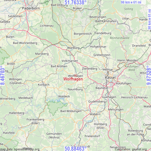
Wolfhagen GPS coordinates[2]
51° 19' 33.996" North, 9° 10' 12.54" East
| Map corner | latitude | longitude |
|---|---|---|
| Upper-left | 51.76338°, | 8.46703° |
| Center: | 51.32611°, | 9.17015° |
| Lower-right: | 50.88463°, | 9.87328° |
| Map W x H: | 97.7×97.7 km | = 60.7×60.7mi |
| max Lat: | 55.01917° ⇑36.4% North |
| Wolfhagen: | 51.32611° |
| min Lat: | ⇓63.6% South 47.40724° |
| min Long | Wolfhagen | max Long |
| 5.92978° | 9.17015° | 14.98853° |
| W 37.2%⇐ | ⇒62.8% E |
Elevation
Elevation of Wolfhagen is 283 m = 928 ft, and this is 33.9 m = 111 ft above average elevation for this country.
| Max E: |
1256 m = 4121 ft | 41.2% |
| Wolfhagen | 283 m 928 ft | |
| Avg. | 249.1 m = 817 ft | |
Min E: |
-5 m = -16 ft | 58.8% |
See also: Germany elevation on elevation.city.
Geographical zone
Wolfhagen is located in North temperate zone (between Tropic of Cancer and the Arctic Circle). Distance of this North polar circle is 1694.2 km =1052.7 mi to North.| Distance of | km | miles | from Wolfhagen |
|---|---|---|---|
| North Pole | 4300.1 | 2672 | to North |
| Arctic Circle | 1694.2 | 1052.7 | to North |
| Tropic Cancer | 3101 | 1926.9 | to South |
| Equator | 5706.9 | 3546.1 | to South |


Nearby cities:
15 places around Wolfhagen: (largest is in red/bold)
• Bad Arolsen
12.4 km =7.7 mi,  298°
298°
• Baunatal
18.5 km =11.5 mi,  116°
116°
• Breuna
10 km =6.2 mi,  5°
5°
• Calden
18.6 km =11.6 mi,  60°
60°
• Hemfurth-Edersee
18.5 km =11.5 mi,  205°
205°
• Liebenau
20.5 km =12.7 mi,  22°
22°
• Martinhagen
9.2 km =5.7 mi, 118°
• Naumburg
8.7 km =5.4 mi,  182°
182°
• Niedenstein
14.2 km =8.8 mi,  136°
136°
• Rhoden
19.7 km =12.2 mi,  326°
326°
• Sachsenhausen
14.5 km =9 mi,  230°
230°
• Volkmarsen
9.9 km =6.2 mi,  338°
338°
• Waldeck
15.3 km =9.5 mi, 209°
• Warburg
18.3 km =11.4 mi,  354°
354°
• Zierenberg
10.3 km =6.4 mi, 62°
Sources, notices
• [Note1] Compared only with cities in Germany existing in our database
• [Src1] Map data: © OpenStreetMap contributors (CC-BY-SA)
• [Src2] Other city data from geonames.org with taken over terms of usage.
• [Src3] Geographical zone / Annual Mean Temperature by Robert A. Rohde @ Wikipedia
