Zierenberg geodata
Zierenberg (Hesse) is a populated place; located in Germany in Europe/Berlin (GMT+2) time zone. With population of 6,782 people, there are 2240 cities with bigger population in this country. Compared to other cities in Germany, 64.3% of cities are located further ↓South; 60.7% of cities are located further →East and 57.6% of cities have lower elevation than Zierenberg. Note1
Administrative division(s):
- Level 1: Hesse
- Level 2: Regierungsbezirk Kassel
- Level 3: Landkreis Kassel
- Level 4: Zierenberg


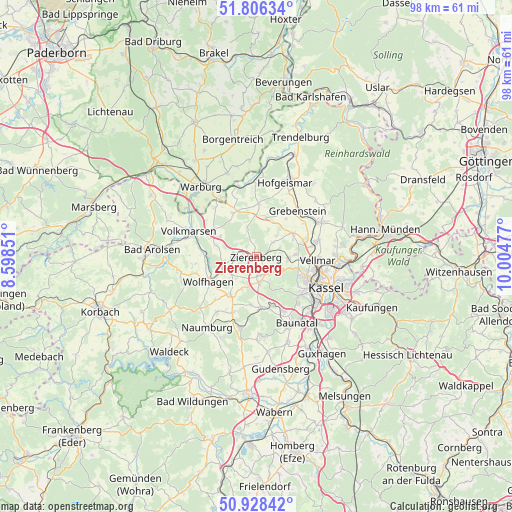
Zierenberg GPS coordinates[2]
51° 22' 10.128" North, 9° 18' 5.904" East
| Map corner | latitude | longitude |
|---|---|---|
| Upper-left | 51.80634°, | 8.59851° |
| Center: | 51.36948°, | 9.30164° |
| Lower-right: | 50.92842°, | 10.00477° |
| Map W x H: | 97.6×97.6 km | = 60.6×60.6mi |
| max Lat: | 55.01917° ⇑35.7% North |
| Zierenberg: | 51.36948° |
| min Lat: | ⇓64.3% South 47.40724° |
| min Long | Zierenberg | max Long |
| 5.92978° | 9.30164° | 14.98853° |
| W 39.3%⇐ | ⇒60.7% E |
Elevation
Elevation of Zierenberg is 276 m = 906 ft, and this is 26.9 m = 88 ft above average elevation for this country.
| Max E: |
1256 m = 4121 ft | 42.4% |
| Zierenberg | 276 m 906 ft | |
| Avg. | 249.1 m = 817 ft | |
Min E: |
-5 m = -16 ft | 57.6% |
See also: Germany elevation on elevation.city.
Geographical zone
Zierenberg is located in North temperate zone (between Tropic of Cancer and the Arctic Circle). Distance of this North polar circle is 1689.4 km =1049.7 mi to North.| Distance of | km | miles | from Zierenberg |
|---|---|---|---|
| North Pole | 4295.3 | 2669 | to North |
| Arctic Circle | 1689.4 | 1049.7 | to North |
| Tropic Cancer | 3105.8 | 1929.9 | to South |
| Equator | 5711.8 | 3549.1 | to South |


Nearby cities:
15 places around Zierenberg: (largest is in red/bold)
• Baunatal
15 km =9.3 mi,  150°
150°
• Breuna
9.6 km =6 mi,  302°
302°
• Calden
8.3 km =5.2 mi,  57°
57°
• Espenau
12.1 km =7.5 mi,  75°
75°
• Grebenstein
11.5 km =7.1 mi,  41°
41°
• Hofgeismar
15.2 km =9.4 mi,  22°
22°
• Immenhausen
14 km =8.7 mi, 62°
• Kassel
15 km =9.3 mi,  113°
113°
• Liebenau
14.2 km =8.8 mi,  354°
354°
• Martinhagen
9.2 km =5.7 mi,  186°
186°
• Niedenstein
15.1 km =9.4 mi,  177°
177°
• Udenhausen
15.4 km =9.6 mi,  46°
46°
• Vellmar
12.4 km =7.7 mi,  95°
95°
• Volkmarsen
13.5 km =8.4 mi,  289°
289°
• Wolfhagen
10.3 km =6.4 mi,  242°
242°
Sources, notices
• [Note1] Compared only with cities in Germany existing in our database
• [Src1] Map data: © OpenStreetMap contributors (CC-BY-SA)
• [Src2] Other city data from geonames.org with taken over terms of usage.
• [Src3] Geographical zone / Annual Mean Temperature by Robert A. Rohde @ Wikipedia
