Calden geodata
Calden (Hesse) is a seat of a fourth-order administrative division; located in Germany in Europe/Berlin (GMT+2) time zone. With population of 7,752 people, there are 1997 cities with bigger population in this country. Compared to other cities in Germany, 64.9% of cities are located further ↓South; 59.2% of cities are located further →East and 51.7% of cities have lower elevation than Calden. Note1
Administrative division(s):
- Level 1: Hesse
- Level 2: Regierungsbezirk Kassel
- Level 3: Landkreis Kassel
- Level 4: Calden


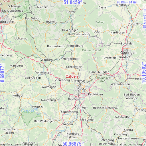
Calden GPS coordinates[2]
51° 24' 33.948" North, 9° 24' 6.804" East
| Map corner | latitude | longitude |
|---|---|---|
| Upper-left | 51.8459°, | 8.69877° |
| Center: | 51.40943°, | 9.40189° |
| Lower-right: | 50.96875°, | 10.10502° |
| Map W x H: | 97.5×97.5 km | = 60.6×60.6mi |
| max Lat: | 55.01917° ⇑35.1% North |
| Calden: | 51.40943° |
| min Lat: | ⇓64.9% South 47.40724° |
| min Long | Calden | max Long |
| 5.92978° | 9.40189° | 14.98853° |
| W 40.8%⇐ | ⇒59.2% E |
Elevation
Elevation of Calden is 238 m = 781 ft, and this is 11.1 m = 36 ft below average elevation for this country.
| Max E: |
1256 m = 4121 ft | 48.3% |
| Avg. | 249.1 m = 817 ft | |
| Calden | 238 m = 781 ft | |
Min E: |
-5 m = -16 ft | 51.7% |
See also: Germany elevation on elevation.city.
Geographical zone
Calden is located in North temperate zone (between Tropic of Cancer and the Arctic Circle). Distance of this North polar circle is 1685 km =1047 mi to North.| Distance of | km | miles | from Calden |
|---|---|---|---|
| North Pole | 4290.9 | 2666.2 | to North |
| Arctic Circle | 1685 | 1047 | to North |
| Tropic Cancer | 3110.3 | 1932.7 | to South |
| Equator | 5716.2 | 3551.9 | to South |


Nearby cities:
15 places around Calden: (largest is in red/bold)
• Baunatal
17.5 km =10.9 mi,  178°
178°
• Breuna
15.1 km =9.4 mi,  272°
272°
• Espenau
4.9 km =3 mi,  106°
106°
• Fuldabrück
16.9 km =10.5 mi,  160°
160°
• Fuldatal
11.8 km =7.3 mi,  104°
104°
• Grebenstein
4.2 km =2.6 mi,  10°
10°
• Hannoversch Münden
17.2 km =10.7 mi,  87°
87°
• Hofgeismar
9.7 km =6 mi,  353°
353°
• Immenhausen
5.8 km =3.6 mi,  69°
69°
• Kassel
12.4 km =7.7 mi,  146°
146°
• Liebenau
12.8 km =8 mi,  319°
319°
• Martinhagen
15.8 km =9.8 mi,  210°
210°
• Udenhausen
7.4 km =4.6 mi,  35°
35°
• Vellmar
7.9 km =4.9 mi,  136°
136°
• Zierenberg
8.3 km =5.2 mi,  237°
237°
Sources, notices
• [Note1] Compared only with cities in Germany existing in our database
• [Src1] Map data: © OpenStreetMap contributors (CC-BY-SA)
• [Src2] Other city data from geonames.org with taken over terms of usage.
• [Src3] Geographical zone / Annual Mean Temperature by Robert A. Rohde @ Wikipedia
