Markranstädt geodata
Markranstädt (Saxony) is a populated place; located in Germany in Europe/Berlin (GMT+2) time zone. With population of 13,053 people, there are 1235 cities with bigger population in this country. Compared to other cities in Germany, 63.3% of cities are located further ↓South; 84.9% of cities are located further ←West and 64.1% of cities have higher elevation than Markranstädt. Note1


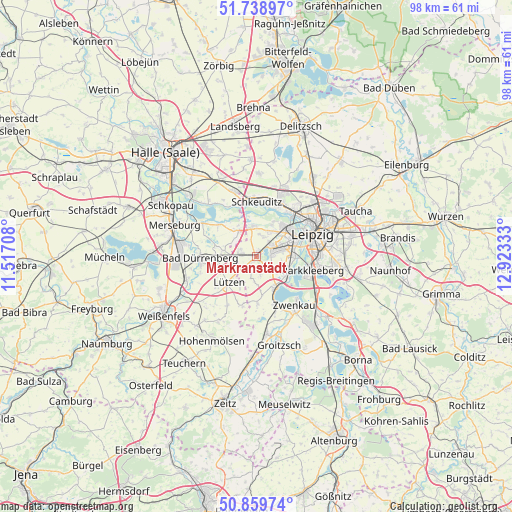
Markranstädt GPS coordinates[2]
51° 18' 5.256" North, 12° 13' 12.72" East
| Map corner | latitude | longitude |
|---|---|---|
| Upper-left | 51.73897°, | 11.51708° |
| Center: | 51.30146°, | 12.2202° |
| Lower-right: | 50.85974°, | 12.92333° |
| Map W x H: | 97.8×97.8 km | = 60.8×60.8mi |
| max Lat: | 55.01917° ⇑36.7% North |
| Markranstädt: | 51.30146° |
| min Lat: | ⇓63.3% South 47.40724° |
| min Long | Markranstädt | max Long |
| 5.92978° | 12.2202° | 14.98853° |
| W 84.9%⇐ | ⇒15.1% E |
Elevation
Elevation of Markranstädt is 126 m = 413 ft, and this is 123.1 m = 404 ft below average elevation for this country.
| Max E: |
1256 m = 4121 ft | 64.1% |
| Avg. | 249.1 m = 817 ft | |
| Markranstädt | 126 m = 413 ft | |
Min E: |
-5 m = -16 ft | 35.9% |
See also: Germany elevation on elevation.city.
Geographical zone
Markranstädt is located in North temperate zone (between Tropic of Cancer and the Arctic Circle). Distance of this North polar circle is 1697 km =1054.5 mi to North.| Distance of | km | miles | from Markranstädt |
|---|---|---|---|
| North Pole | 4302.9 | 2673.7 | to North |
| Arctic Circle | 1697 | 1054.5 | to North |
| Tropic Cancer | 3098.3 | 1925.2 | to South |
| Equator | 5704.2 | 3544.4 | to South |


Nearby cities:
15 places around Markranstädt: (largest is in red/bold)
• Bad Dürrenberg
10.8 km =6.7 mi,  266°
266°
• Ermlitz
10.9 km =6.8 mi,  337°
337°
• Großgörschen
9.8 km =6.1 mi,  195°
195°
• Großlehna
3.4 km =2.1 mi,  280°
280°
• Günthersdorf
6 km =3.7 mi,  325°
325°
• Kitzen
8.9 km =5.5 mi,  178°
178°
• Kötschlitz
6.9 km =4.3 mi, 330°
• Kötzschau
6.4 km =4 mi, 281°
• Lützen
7.4 km =4.6 mi,  227°
227°
• Markkleeberg
10.7 km =6.6 mi,  105°
105°
• Röcken
9.9 km =6.2 mi, 227°
• Schkeuditz
10.6 km =6.6 mi,  0°
0°
• Starsiedel
10.9 km =6.8 mi,  211°
211°
• Tollwitz
8.7 km =5.4 mi,  258°
258°
• Zöschen
9.6 km =6 mi,  311°
311°
Sources, notices
• [Note1] Compared only with cities in Germany existing in our database
• [Src1] Map data: © OpenStreetMap contributors (CC-BY-SA)
• [Src2] Other city data from geonames.org with taken over terms of usage.
• [Src3] Geographical zone / Annual Mean Temperature by Robert A. Rohde @ Wikipedia
