Günthersdorf geodata
Günthersdorf (Saxony-Anhalt) is a populated place; located in Germany in Europe/Berlin (GMT+2) time zone. With population of 1,179 people, there are 6620 cities with bigger population in this country. Compared to other cities in Germany, 63.9% of cities are located further ↓South; 84.2% of cities are located further ←West and 66.2% of cities have higher elevation than Günthersdorf. Note1


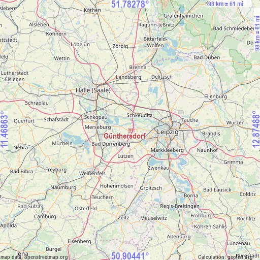
Günthersdorf GPS coordinates[2]
51° 20' 44.52" North, 12° 10' 18.3" East
| Map corner | latitude | longitude |
|---|---|---|
| Upper-left | 51.78278°, | 11.46863° |
| Center: | 51.3457°, | 12.17175° |
| Lower-right: | 50.90441°, | 12.87488° |
| Map W x H: | 97.7×97.7 km | = 60.7×60.7mi |
| max Lat: | 55.01917° ⇑36.1% North |
| Günthersdorf: | 51.3457° |
| min Lat: | ⇓63.9% South 47.40724° |
| min Long | Günthersdorf | max Long |
| 5.92978° | 12.17175° | 14.98853° |
| W 84.2%⇐ | ⇒15.8% E |
Elevation
Elevation of Günthersdorf is 113 m = 371 ft, and this is 136.1 m = 447 ft below average elevation for this country.
| Max E: |
1256 m = 4121 ft | 66.2% |
| Avg. | 249.1 m = 817 ft | |
| Günthersdorf | 113 m = 371 ft | |
Min E: |
-5 m = -16 ft | 33.8% |
See also: Germany elevation on elevation.city.
Geographical zone
Günthersdorf is located in North temperate zone (between Tropic of Cancer and the Arctic Circle). Distance of this North polar circle is 1692.1 km =1051.4 mi to North.| Distance of | km | miles | from Günthersdorf |
|---|---|---|---|
| North Pole | 4298 | 2670.7 | to North |
| Arctic Circle | 1692.1 | 1051.4 | to North |
| Tropic Cancer | 3103.2 | 1928.2 | to South |
| Equator | 5709.1 | 3547.5 | to South |


Nearby cities:
15 places around Günthersdorf: (largest is in red/bold)
• Bad Dürrenberg
9.2 km =5.7 mi,  232°
232°
• Ermlitz
5.2 km =3.2 mi,  350°
350°
• Großkugel
8.2 km =5.1 mi, 347°
• Großlehna
4.3 km =2.7 mi,  179°
179°
• Kötschlitz
1 km =0.6 mi,  357°
357°
• Kötzschau
4.7 km =2.9 mi,  217°
217°
• Lochau
10 km =6.2 mi,  304°
304°
• Lützen
10.1 km =6.3 mi,  191°
191°
• Markranstädt
6 km =3.7 mi,  145°
145°
• Ostrau
9 km =5.6 mi,  243°
243°
• Raßnitz
7.4 km =4.6 mi,  312°
312°
• Schkeuditz
6.6 km =4.1 mi,  31°
31°
• Tollwitz
8.4 km =5.2 mi, 217°
• Wallendorf
6.9 km =4.3 mi,  283°
283°
• Zöschen
4.1 km =2.5 mi,  289°
289°
Sources, notices
• [Note1] Compared only with cities in Germany existing in our database
• [Src1] Map data: © OpenStreetMap contributors (CC-BY-SA)
• [Src2] Other city data from geonames.org with taken over terms of usage.
• [Src3] Geographical zone / Annual Mean Temperature by Robert A. Rohde @ Wikipedia
