Tollwitz geodata
Tollwitz (Saxony-Anhalt) is a populated place; located in Germany in Europe/Berlin (GMT+2) time zone. With population of 1,252 people, there are 6435 cities with bigger population in this country. Compared to other cities in Germany, 63% of cities are located further ↓South; 83.2% of cities are located further ←West and 67.4% of cities have higher elevation than Tollwitz. Note1


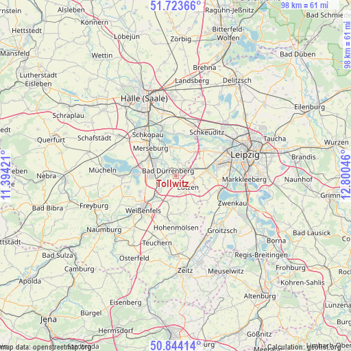
Tollwitz GPS coordinates[2]
51° 17' 9.636" North, 12° 5' 50.388" East
| Map corner | latitude | longitude |
|---|---|---|
| Upper-left | 51.72366°, | 11.39421° |
| Center: | 51.28601°, | 12.09733° |
| Lower-right: | 50.84414°, | 12.80046° |
| Map W x H: | 97.8×97.8 km | = 60.8×60.8mi |
| max Lat: | 55.01917° ⇑37% North |
| Tollwitz: | 51.28601° |
| min Lat: | ⇓63% South 47.40724° |
| min Long | Tollwitz | max Long |
| 5.92978° | 12.09733° | 14.98853° |
| W 83.2%⇐ | ⇒16.8% E |
Elevation
Elevation of Tollwitz is 105 m = 344 ft, and this is 144.1 m = 473 ft below average elevation for this country.
| Max E: |
1256 m = 4121 ft | 67.4% |
| Avg. | 249.1 m = 817 ft | |
| Tollwitz | 105 m = 344 ft | |
Min E: |
-5 m = -16 ft | 32.6% |
See also: Germany elevation on elevation.city.
Geographical zone
Tollwitz is located in North temperate zone (between Tropic of Cancer and the Arctic Circle). Distance of this North polar circle is 1698.7 km =1055.5 mi to North.| Distance of | km | miles | from Tollwitz |
|---|---|---|---|
| North Pole | 4304.6 | 2674.8 | to North |
| Arctic Circle | 1698.7 | 1055.5 | to North |
| Tropic Cancer | 3096.6 | 1924.1 | to South |
| Equator | 5702.5 | 3543.4 | to South |


Nearby cities:
15 places around Tollwitz: (largest is in red/bold)
• Bad Dürrenberg
2.4 km =1.5 mi,  295°
295°
• Dehlitz
8.1 km =5 mi,  220°
220°
• Großkorbetha
5.5 km =3.4 mi,  238°
238°
• Großlehna
5.7 km =3.5 mi,  65°
65°
• Kötzschau
3.7 km =2.3 mi,  38°
38°
• Leuna
6.7 km =4.2 mi, 302°
• Lützen
4.5 km =2.8 mi,  136°
136°
• Ostrau
3.8 km =2.4 mi,  311°
311°
• Rippach
7 km =4.3 mi,  199°
199°
• Röcken
5.2 km =3.2 mi,  165°
165°
• Schkortleben
7.3 km =4.5 mi,  229°
229°
• Spergau
5.2 km =3.2 mi,  279°
279°
• Starsiedel
8.2 km =5.1 mi,  159°
159°
• Wengelsdorf
3.9 km =2.4 mi,  261°
261°
• Zöschen
8.1 km =5 mi,  9°
9°
Sources, notices
• [Note1] Compared only with cities in Germany existing in our database
• [Src1] Map data: © OpenStreetMap contributors (CC-BY-SA)
• [Src2] Other city data from geonames.org with taken over terms of usage.
• [Src3] Geographical zone / Annual Mean Temperature by Robert A. Rohde @ Wikipedia
