Knittelsheim geodata
Knittelsheim (Rheinland-Pfalz) is a seat of a fourth-order administrative division; located in Germany in Europe/Berlin (GMT+2) time zone. With population of 1,026 people, there are 7088 cities with bigger population in this country. Compared to other cities in Germany, 80.4% of cities are located further ↑North; 73.5% of cities are located further →East and 64.1% of cities have higher elevation than Knittelsheim. Note1
Administrative division(s):
- Level 1: Rheinland-Pfalz
- Level 3: Landkreis Germersheim
- Level 4: Knittelsheim


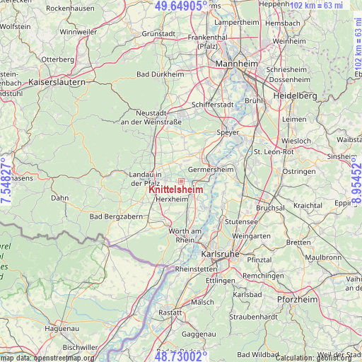
Knittelsheim GPS coordinates[2]
49° 11' 30.012" North, 8° 15' 5.004" East
| Map corner | latitude | longitude |
|---|---|---|
| Upper-left | 49.64905°, | 7.54827° |
| Center: | 49.19167°, | 8.25139° |
| Lower-right: | 48.73002°, | 8.95452° |
| Map W x H: | 102.2×102.2 km | = 63.5×63.5mi |
| max Lat: | 55.01917° ⇑80.4% North |
| Knittelsheim: | 49.19167° |
| min Lat: | ⇓19.6% South 47.40724° |
| min Long | Knittelsheim | max Long |
| 5.92978° | 8.25139° | 14.98853° |
| W 26.5%⇐ | ⇒73.5% E |
Elevation
Elevation of Knittelsheim is 126 m = 413 ft, and this is 123.1 m = 404 ft below average elevation for this country.
| Max E: |
1256 m = 4121 ft | 64.1% |
| Avg. | 249.1 m = 817 ft | |
| Knittelsheim | 126 m = 413 ft | |
Min E: |
-5 m = -16 ft | 35.9% |
See also: Germany elevation on elevation.city.
Geographical zone
Knittelsheim is located in North temperate zone (between Tropic of Cancer and the Arctic Circle). Distance of this North polar circle is 1931.6 km =1200.2 mi to North.| Distance of | km | miles | from Knittelsheim |
|---|---|---|---|
| North Pole | 4537.5 | 2819.5 | to North |
| Arctic Circle | 1931.6 | 1200.2 | to North |
| Tropic Cancer | 2863.7 | 1779.4 | to South |
| Equator | 5469.6 | 3398.7 | to South |


Nearby cities:
15 places around Knittelsheim: (largest is in red/bold)
• Bellheim
2.2 km =1.4 mi,  70°
70°
• Bornheim
7.3 km =4.5 mi,  298°
298°
• Essingen
7.4 km =4.6 mi,  311°
311°
• Herxheim
5.7 km =3.5 mi,  208°
208°
• Herxheimweyher
4.4 km =2.7 mi,  176°
176°
• Hochstadt
6.9 km =4.3 mi,  333°
333°
• Hördt
6.2 km =3.9 mi,  117°
117°
• Kuhardt
6.9 km =4.3 mi,  138°
138°
• Lustadt
6.1 km =3.8 mi,  15°
15°
• Offenbach an der Queich
3.9 km =2.4 mi,  276°
276°
• Ottersheim
1.4 km =0.9 mi,  268°
268°
• Rülzheim
5.2 km =3.2 mi, 144°
• Weingarten
8 km =5 mi, 18°
• Westheim
8 km =5 mi,  40°
40°
• Zeiskam
4.6 km =2.9 mi,  356°
356°
Sources, notices
• [Note1] Compared only with cities in Germany existing in our database
• [Src1] Map data: © OpenStreetMap contributors (CC-BY-SA)
• [Src2] Other city data from geonames.org with taken over terms of usage.
• [Src3] Geographical zone / Annual Mean Temperature by Robert A. Rohde @ Wikipedia
