Lülsfeld geodata
Lülsfeld (Bavaria) is a seat of a fourth-order administrative division; located in Germany in Europe/Berlin (GMT+2) time zone. With population of 844 people, there are 7728 cities with bigger population in this country. Compared to other cities in Germany, 67.2% of cities are located further ↑North; 55.9% of cities are located further ←West and 53.4% of cities have lower elevation than Lülsfeld. Note1
Administrative division(s):
- Level 1: Bavaria
- Level 2: Regierungsbezirk Unterfranken
- Level 3: Landkreis Schweinfurt
- Level 4: Lülsfeld


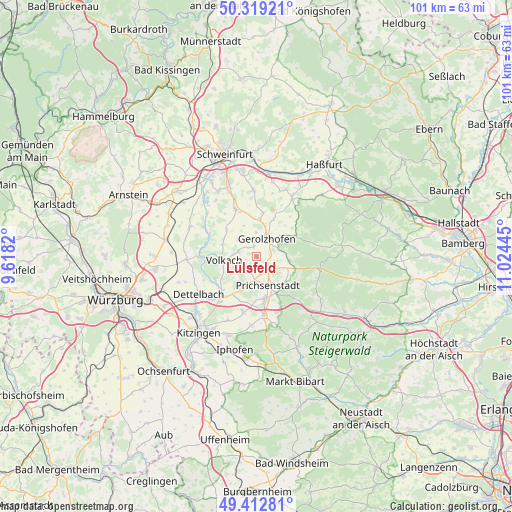
Lülsfeld GPS coordinates[2]
49° 52' 5.304" North, 10° 19' 16.752" East
| Map corner | latitude | longitude |
|---|---|---|
| Upper-left | 50.31921°, | 9.6182° |
| Center: | 49.86814°, | 10.32132° |
| Lower-right: | 49.41281°, | 11.02445° |
| Map W x H: | 100.8×100.8 km | = 62.6×62.6mi |
| max Lat: | 55.01917° ⇑67.2% North |
| Lülsfeld: | 49.86814° |
| min Lat: | ⇓32.8% South 47.40724° |
| min Long | Lülsfeld | max Long |
| 5.92978° | 10.32132° | 14.98853° |
| W 55.9%⇐ | ⇒44.1% E |
Elevation
Elevation of Lülsfeld is 249 m = 817 ft, and this is 0.099999999999994 m = 0 ft below average elevation for this country.
| Max E: |
1256 m = 4121 ft | 46.6% |
| Avg. | 249.1 m = 817 ft | |
| Lülsfeld | 249 m = 817 ft | |
Min E: |
-5 m = -16 ft | 53.4% |
See also: Germany elevation on elevation.city.
Geographical zone
Lülsfeld is located in North temperate zone (between Tropic of Cancer and the Arctic Circle). Distance of this North polar circle is 1856.4 km =1153.5 mi to North.| Distance of | km | miles | from Lülsfeld |
|---|---|---|---|
| North Pole | 4462.2 | 2772.7 | to North |
| Arctic Circle | 1856.4 | 1153.5 | to North |
| Tropic Cancer | 2938.9 | 1826.1 | to South |
| Equator | 5544.8 | 3445.4 | to South |


Nearby cities:
15 places around Lülsfeld: (largest is in red/bold)
• Abtswind
11.5 km =7.1 mi,  161°
161°
• Dingolshausen
6.6 km =4.1 mi,  48°
48°
• Frankenwinheim
2.2 km =1.4 mi,  346°
346°
• Gerolzhofen
4.1 km =2.5 mi,  28°
28°
• Kleinlangheim
11.1 km =6.9 mi,  193°
193°
• Kolitzheim
8.3 km =5.2 mi,  310°
310°
• Michelau
8.9 km =5.5 mi,  62°
62°
• Nordheim
9.8 km =6.1 mi,  263°
263°
• Oberschwarzach
6.4 km =4 mi,  97°
97°
• Prichsenstadt
5.7 km =3.5 mi, 160°
• Rüdenhausen
11.5 km =7.1 mi,  173°
173°
• Sommerach
9.2 km =5.7 mi,  241°
241°
• Sulzheim
9.1 km =5.7 mi,  5°
5°
• Volkach
6.7 km =4.2 mi,  265°
265°
• Wiesentheid
8.4 km =5.2 mi, 168°
Sources, notices
• [Note1] Compared only with cities in Germany existing in our database
• [Src1] Map data: © OpenStreetMap contributors (CC-BY-SA)
• [Src2] Other city data from geonames.org with taken over terms of usage.
• [Src3] Geographical zone / Annual Mean Temperature by Robert A. Rohde @ Wikipedia
