Volkach geodata
Volkach (Bavaria) is a populated place; located in Germany in Europe/Berlin (GMT+2) time zone. With population of 9,585 people, there are 1686 cities with bigger population in this country. Compared to other cities in Germany, 67.5% of cities are located further ↑North; 53.9% of cities are located further ←West and 53.1% of cities have higher elevation than Volkach. Note1
Administrative division(s):
- Level 1: Bavaria
- Level 2: Regierungsbezirk Unterfranken
- Level 3: Landkreis Kitzingen
- Level 4: Volkach


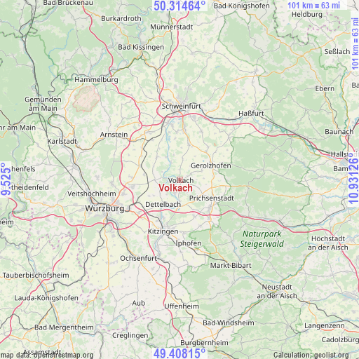
Volkach GPS coordinates[2]
49° 51' 48.672" North, 10° 13' 41.268" East
| Map corner | latitude | longitude |
|---|---|---|
| Upper-left | 50.31464°, | 9.525° |
| Center: | 49.86352°, | 10.22813° |
| Lower-right: | 49.40815°, | 10.93126° |
| Map W x H: | 100.8×100.8 km | = 62.6×62.6mi |
| max Lat: | 55.01917° ⇑67.5% North |
| Volkach: | 49.86352° |
| min Lat: | ⇓32.5% South 47.40724° |
| min Long | Volkach | max Long |
| 5.92978° | 10.22813° | 14.98853° |
| W 53.9%⇐ | ⇒46.1% E |
Elevation
Elevation of Volkach is 203 m = 666 ft, and this is 46.1 m = 151 ft below average elevation for this country.
| Max E: |
1256 m = 4121 ft | 53.1% |
| Avg. | 249.1 m = 817 ft | |
| Volkach | 203 m = 666 ft | |
Min E: |
-5 m = -16 ft | 46.9% |
See also: Germany elevation on elevation.city.
Geographical zone
Volkach is located in North temperate zone (between Tropic of Cancer and the Arctic Circle). Distance of this North polar circle is 1856.9 km =1153.8 mi to North.| Distance of | km | miles | from Volkach |
|---|---|---|---|
| North Pole | 4462.8 | 2773.1 | to North |
| Arctic Circle | 1856.9 | 1153.8 | to North |
| Tropic Cancer | 2938.4 | 1825.8 | to South |
| Equator | 5544.3 | 3445.1 | to South |


Nearby cities:
15 places around Volkach: (largest is in red/bold)
• Albertshofen
11.6 km =7.2 mi,  202°
202°
• Dettelbach
8.1 km =5 mi,  213°
213°
• Frankenwinheim
6.7 km =4.2 mi,  66°
66°
• Gerolzhofen
9.5 km =5.9 mi,  64°
64°
• Kleinlangheim
11.1 km =6.9 mi,  158°
158°
• Kolitzheim
5.9 km =3.7 mi,  3°
3°
• Lülsfeld
6.7 km =4.2 mi,  85°
85°
• Nordheim
3.1 km =1.9 mi,  260°
260°
• Oberpleichfeld
10.2 km =6.3 mi,  278°
278°
• Prichsenstadt
9.9 km =6.2 mi,  119°
119°
• Prosselsheim
7.3 km =4.5 mi,  269°
269°
• Schwanfeld
9.1 km =5.7 mi,  315°
315°
• Sommerach
4.1 km =2.5 mi, 200°
• Wiesentheid
11.4 km =7.1 mi,  132°
132°
• Wipfeld
7.4 km =4.6 mi, 323°
Sources, notices
• [Note1] Compared only with cities in Germany existing in our database
• [Src1] Map data: © OpenStreetMap contributors (CC-BY-SA)
• [Src2] Other city data from geonames.org with taken over terms of usage.
• [Src3] Geographical zone / Annual Mean Temperature by Robert A. Rohde @ Wikipedia
