Frankenwinheim geodata
Frankenwinheim (Bavaria) is a seat of a fourth-order administrative division; located in Germany in Europe/Berlin (GMT+2) time zone. With population of 1,025 people, there are 7091 cities with bigger population in this country. Compared to other cities in Germany, 66.8% of cities are located further ↑North; 55.6% of cities are located further ←West and 50.6% of cities have lower elevation than Frankenwinheim. Note1
Administrative division(s):
- Level 1: Bavaria
- Level 2: Regierungsbezirk Unterfranken
- Level 3: Landkreis Schweinfurt
- Level 4: Frankenwinheim


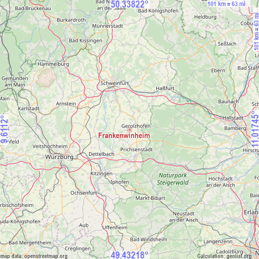
Frankenwinheim GPS coordinates[2]
49° 53' 14.388" North, 10° 18' 51.552" East
| Map corner | latitude | longitude |
|---|---|---|
| Upper-left | 50.33822°, | 9.6112° |
| Center: | 49.88733°, | 10.31432° |
| Lower-right: | 49.43218°, | 11.01745° |
| Map W x H: | 100.7×100.7 km | = 62.6×62.6mi |
| max Lat: | 55.01917° ⇑66.8% North |
| Frankenwinheim: | 49.88733° |
| min Lat: | ⇓33.2% South 47.40724° |
| min Long | Frankenwinheim | max Long |
| 5.92978° | 10.31432° | 14.98853° |
| W 55.6%⇐ | ⇒44.4% E |
Elevation
Elevation of Frankenwinheim is 230 m = 755 ft, and this is 19.1 m = 63 ft below average elevation for this country.
| Max E: |
1256 m = 4121 ft | 49.4% |
| Avg. | 249.1 m = 817 ft | |
| Frankenwinheim | 230 m = 755 ft | |
Min E: |
-5 m = -16 ft | 50.6% |
See also: Germany elevation on elevation.city.
Geographical zone
Frankenwinheim is located in North temperate zone (between Tropic of Cancer and the Arctic Circle). Distance of this North polar circle is 1854.2 km =1152.1 mi to North.| Distance of | km | miles | from Frankenwinheim |
|---|---|---|---|
| North Pole | 4460.1 | 2771.4 | to North |
| Arctic Circle | 1854.2 | 1152.1 | to North |
| Tropic Cancer | 2941 | 1827.5 | to South |
| Equator | 5547 | 3446.7 | to South |


Nearby cities:
15 places around Frankenwinheim: (largest is in red/bold)
• Dingolshausen
5.9 km =3.7 mi,  68°
68°
• Donnersdorf
11.5 km =7.1 mi,  39°
39°
• Gerolzhofen
2.8 km =1.7 mi,  59°
59°
• Grettstadt
10.7 km =6.6 mi,  0°
0°
• Kolitzheim
6.7 km =4.2 mi,  299°
299°
• Lülsfeld
2.2 km =1.4 mi,  166°
166°
• Michelau
8.6 km =5.3 mi,  76°
76°
• Nordheim
9.8 km =6.1 mi,  250°
250°
• Oberschwarzach
7.5 km =4.7 mi,  113°
113°
• Prichsenstadt
7.9 km =4.9 mi,  162°
162°
• Sommerach
10 km =6.2 mi,  229°
229°
• Sulzheim
7.1 km =4.4 mi,  11°
11°
• Volkach
6.7 km =4.2 mi, 246°
• Wiesentheid
10.6 km =6.6 mi, 167°
• Wipfeld
11.1 km =6.9 mi,  287°
287°
Sources, notices
• [Note1] Compared only with cities in Germany existing in our database
• [Src1] Map data: © OpenStreetMap contributors (CC-BY-SA)
• [Src2] Other city data from geonames.org with taken over terms of usage.
• [Src3] Geographical zone / Annual Mean Temperature by Robert A. Rohde @ Wikipedia
