Barth geodata
Barth (Mecklenburg-Vorpommern) is a populated place; located in Germany in Europe/Berlin (GMT+2) time zone. With population of 9,298 people, there are 1739 cities with bigger population in this country. Compared to other cities in Germany, 97% of cities are located further ↓South; 90% of cities are located further ←West and 98.6% of cities have higher elevation than Barth. Note1
Administrative division(s):
- Level 1: Mecklenburg-Vorpommern
- Level 3: Vorpommern-Rügen
- Level 4: Barth


Barth GPS coordinates[2]
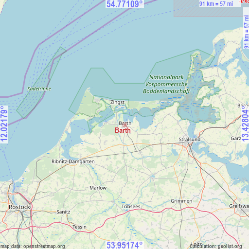
54° 21' 48.456" North, 12° 43' 29.676" East
| Map corner | latitude | longitude |
|---|---|---|
| Upper-left | 54.77109°, | 12.02179° |
| Center: | 54.36346°, | 12.72491° |
| Lower-right: | 53.95174°, | 13.42804° |
| Map W x H: | 91.1×91.1 km | = 56.6×56.6mi |
| max Lat: | 55.01917° ⇑3% North |
| Barth: | 54.36346° |
| min Lat: | ⇓97% South 47.40724° |
| min Long | Barth | max Long |
| 5.92978° | 12.72491° | 14.98853° |
| W 90%⇐ | ⇒10% E |
Elevation
Elevation of Barth is 1 m = 3 ft, and this is 248.1 m = 814 ft below average elevation for this country.
| Max E: |
1256 m = 4121 ft | 98.6% |
| Avg. | 249.1 m = 817 ft | |
| Barth | 1 m = 3 ft | |
Min E: |
-5 m = -16 ft | 1.4% |
See also: Germany elevation on elevation.city.
Geographical zone
Barth is located in North temperate zone (between Tropic of Cancer and the Arctic Circle). Distance of this North polar circle is 1356.5 km =842.9 mi to North.| Distance of | km | miles | from Barth |
|---|---|---|---|
| North Pole | 3962.4 | 2462.1 | to North |
| Arctic Circle | 1356.5 | 842.9 | to North |
| Tropic Cancer | 3438.7 | 2136.7 | to South |
| Equator | 6044.7 | 3756 | to South |


Nearby cities:
15 places around Barth: (largest is in red/bold)
• Altenpleen
15 km =9.3 mi,  93°
93°
• Born
12.8 km =8 mi,  280°
280°
• Fuhlendorf
8 km =5 mi,  267°
267°
• Groß Mohrdorf
14.7 km =9.1 mi,  79°
79°
• Löbnitz
7.6 km =4.7 mi,  182°
182°
• Niepars
14 km =8.7 mi,  112°
112°
• Ostseebad Prerow
13.2 km =8.2 mi,  313°
313°
• Pantelitz
17.3 km =10.7 mi, 113°
• Preetz
17.2 km =10.7 mi, 94°
• Pruchten
3.7 km =2.3 mi,  296°
296°
• Saal
15.8 km =9.8 mi,  248°
248°
• Trinwillershagen
14.2 km =8.8 mi,  207°
207°
• Velgast
11.6 km =7.2 mi,  151°
151°
• Wieck
10.6 km =6.6 mi, 298°
• Zingst
8.4 km =5.2 mi,  343°
343°
Sources, notices
• [Note1] Compared only with cities in Germany existing in our database
• [Src1] Map data: © OpenStreetMap contributors (CC-BY-SA)
• [Src2] Other city data from geonames.org with taken over terms of usage.
• [Src3] Geographical zone / Annual Mean Temperature by Robert A. Rohde @ Wikipedia
