Leutkirch geodata
Leutkirch (Baden-Württemberg) is a populated place; located in Germany in Europe/Berlin (GMT+2) time zone. With population of 22,362 people, there are 673 cities with bigger population in this country. Compared to other cities in Germany, 97.4% of cities are located further ↑North; 50.5% of cities are located further ←West and 96.8% of cities have lower elevation than Leutkirch. Note1
Administrative division(s):
- Level 1: Baden-Württemberg
- Level 2: Tübingen Region
- Level 3: Landkreis Ravensburg
- Level 4: Leutkirch im Allgäu


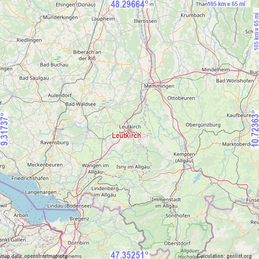
Leutkirch GPS coordinates[2]
47° 49' 36.192" North, 10° 1' 13.8" East
| Map corner | latitude | longitude |
|---|---|---|
| Upper-left | 48.29664°, | 9.31737° |
| Center: | 47.82672°, | 10.0205° |
| Lower-right: | 47.35251°, | 10.72363° |
| Map W x H: | 105×105 km | = 65.2×65.2mi |
| max Lat: | 55.01917° ⇑97.4% North |
| Leutkirch: | 47.82672° |
| min Lat: | ⇓2.6% South 47.40724° |
| min Long | Leutkirch | max Long |
| 5.92978° | 10.0205° | 14.98853° |
| W 50.5%⇐ | ⇒49.5% E |
Elevation
Elevation of Leutkirch is 655 m = 2149 ft, and this is 405.9 m = 1332 ft above average elevation for this country.
| Max E: |
1256 m = 4121 ft | 3.2% |
| Leutkirch | 655 m 2149 ft | |
| Avg. | 249.1 m = 817 ft | |
Min E: |
-5 m = -16 ft | 96.8% |
See also: Germany elevation on elevation.city.
Geographical zone
Leutkirch is located in North temperate zone (between Tropic of Cancer and the Arctic Circle). Distance of this North polar circle is 2083.3 km =1294.5 mi to North.| Distance of | km | miles | from Leutkirch |
|---|---|---|---|
| North Pole | 4689.2 | 2913.7 | to North |
| Arctic Circle | 2083.3 | 1294.5 | to North |
| Tropic Cancer | 2711.9 | 1685.1 | to South |
| Equator | 5317.8 | 3304.3 | to South |


Nearby cities:
15 places around Leutkirch: (largest is in red/bold)
• Aichstetten
8.5 km =5.3 mi,  30°
30°
• Aitrach
12.7 km =7.9 mi,  21°
21°
• Altusried
14.7 km =9.1 mi,  99°
99°
• Bad Wurzach
12.9 km =8 mi,  314°
314°
• Dickenreishausen
17.9 km =11.1 mi,  38°
38°
• Isny
15 km =9.3 mi,  174°
174°
• Kißlegg
11 km =6.8 mi,  247°
247°
• Kronburg
13.4 km =8.3 mi,  49°
49°
• Lautrach
10.8 km =6.7 mi, 42°
• Legau
8.8 km =5.5 mi,  68°
68°
• Tannheim
19.8 km =12.3 mi,  13°
13°
• Wiggensbach
17.9 km =11.1 mi,  119°
119°
• Wolfegg
16.9 km =10.5 mi,  267°
267°
• Wolfertschwenden
19.8 km =12.3 mi, 68°
• Woringen
16.7 km =10.4 mi, 53°
In other languages:
- In German: Leutkirch im Allgäu
- In Russian: Лойткирх-им-Алльгой
- In Chinese: 阿尔戈伊地区洛伊特基希
Sources, notices
• [Note1] Compared only with cities in Germany existing in our database
• [Src1] Map data: © OpenStreetMap contributors (CC-BY-SA)
• [Src2] Other city data from geonames.org with taken over terms of usage.
• [Src3] Geographical zone / Annual Mean Temperature by Robert A. Rohde @ Wikipedia
