Isny geodata
Isny (Baden-Württemberg) is a populated place; located in Germany in Europe/Berlin (GMT+2) time zone. With population of 14,424 people, there are 1096 cities with bigger population in this country. Compared to other cities in Germany, 98.8% of cities are located further ↑North; 50.7% of cities are located further ←West and 98% of cities have lower elevation than Isny. Note1
Administrative division(s):
- Level 1: Baden-Württemberg
- Level 2: Tübingen Region
- Level 3: Landkreis Ravensburg
- Level 4: Isny im Allgäu


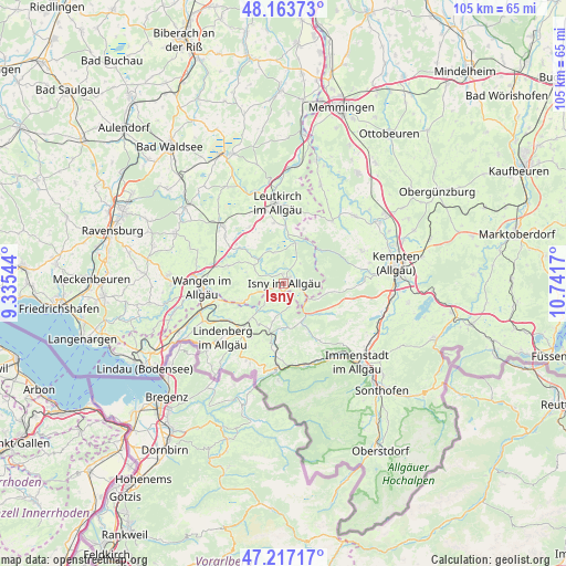
Isny GPS coordinates[2]
47° 41' 33.36" North, 10° 2' 18.852" East
| Map corner | latitude | longitude |
|---|---|---|
| Upper-left | 48.16373°, | 9.33544° |
| Center: | 47.6926°, | 10.03857° |
| Lower-right: | 47.21717°, | 10.7417° |
| Map W x H: | 105.2×105.2 km | = 65.4×65.4mi |
| max Lat: | 55.01917° ⇑98.8% North |
| Isny: | 47.6926° |
| min Lat: | ⇓1.2% South 47.40724° |
| min Long | Isny | max Long |
| 5.92978° | 10.03857° | 14.98853° |
| W 50.7%⇐ | ⇒49.3% E |
Elevation
Elevation of Isny is 707 m = 2320 ft, and this is 457.9 m = 1502 ft above average elevation for this country.
| Max E: |
1256 m = 4121 ft | 2% |
| Isny | 707 m 2320 ft | |
| Avg. | 249.1 m = 817 ft | |
Min E: |
-5 m = -16 ft | 98% |
See also: Germany elevation on elevation.city.
Geographical zone
Isny is located in North temperate zone (between Tropic of Cancer and the Arctic Circle). Distance of this North polar circle is 2098.3 km =1303.8 mi to North.| Distance of | km | miles | from Isny |
|---|---|---|---|
| North Pole | 4704.1 | 2923 | to North |
| Arctic Circle | 2098.3 | 1303.8 | to North |
| Tropic Cancer | 2697 | 1675.8 | to South |
| Equator | 5302.9 | 3295.1 | to South |


Nearby cities:
15 places around Isny: (largest is in red/bold)
• Buchenberg
15 km =9.3 mi,  88°
88°
• Gestratz
6.3 km =3.9 mi,  221°
221°
• Grünenbach
7.5 km =4.7 mi,  197°
197°
• Heimenkirch
12.3 km =7.6 mi,  235°
235°
• Kißlegg
15.8 km =9.8 mi,  312°
312°
• Leutkirch
15 km =9.3 mi,  354°
354°
• Maierhöfen
4.8 km =3 mi,  169°
169°
• Missen-Wilhams
11.8 km =7.3 mi,  150°
150°
• Oberstaufen
15.3 km =9.5 mi,  184°
184°
• Röthenbach
9.1 km =5.7 mi,  212°
212°
• Stiefenhofen
11.4 km =7.1 mi,  193°
193°
• Wangen
15.4 km =9.6 mi,  268°
268°
• Weiler-Simmerberg
15.4 km =9.6 mi, 217°
• Weitnau
8.7 km =5.4 mi,  130°
130°
• Wiggensbach
15.6 km =9.7 mi,  66°
66°
Sources, notices
• [Note1] Compared only with cities in Germany existing in our database
• [Src1] Map data: © OpenStreetMap contributors (CC-BY-SA)
• [Src2] Other city data from geonames.org with taken over terms of usage.
• [Src3] Geographical zone / Annual Mean Temperature by Robert A. Rohde @ Wikipedia
