Gräfenberg geodata
Gräfenberg (Bavaria) is a populated place; located in Germany in Europe/Berlin (GMT+2) time zone. With population of 4,105 people, there are 3226 cities with bigger population in this country. Compared to other cities in Germany, 72.7% of cities are located further ↑North; 70.6% of cities are located further ←West and 80.3% of cities have lower elevation than Gräfenberg. Note1
Administrative division(s):
- Level 1: Bavaria
- Level 2: Upper Franconia
- Level 3: Landkreis Forchheim
- Level 4: Gräfenberg


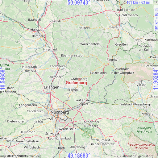
Gräfenberg GPS coordinates[2]
49° 38' 39.336" North, 11° 14' 58.956" East
| Map corner | latitude | longitude |
|---|---|---|
| Upper-left | 50.09743°, | 10.54659° |
| Center: | 49.64426°, | 11.24971° |
| Lower-right: | 49.18683°, | 11.95284° |
| Map W x H: | 101.2×101.2 km | = 62.9×62.9mi |
| max Lat: | 55.01917° ⇑72.7% North |
| Gräfenberg: | 49.64426° |
| min Lat: | ⇓27.3% South 47.40724° |
| min Long | Gräfenberg | max Long |
| 5.92978° | 11.24971° | 14.98853° |
| W 70.6%⇐ | ⇒29.4% E |
Elevation
Elevation of Gräfenberg is 435 m = 1427 ft, and this is 185.9 m = 610 ft above average elevation for this country.
| Max E: |
1256 m = 4121 ft | 19.7% |
| Gräfenberg | 435 m 1427 ft | |
| Avg. | 249.1 m = 817 ft | |
Min E: |
-5 m = -16 ft | 80.3% |
See also: Germany elevation on elevation.city.
Geographical zone
Gräfenberg is located in North temperate zone (between Tropic of Cancer and the Arctic Circle). Distance of this North polar circle is 1881.2 km =1168.9 mi to North.| Distance of | km | miles | from Gräfenberg |
|---|---|---|---|
| North Pole | 4487.1 | 2788.2 | to North |
| Arctic Circle | 1881.2 | 1168.9 | to North |
| Tropic Cancer | 2914 | 1810.7 | to South |
| Equator | 5519.9 | 3429.9 | to South |


Nearby cities:
15 places around Gräfenberg: (largest is in red/bold)
• Dormitz
10.8 km =6.7 mi,  241°
241°
• Effeltrich
11.4 km =7.1 mi,  278°
278°
• Egloffstein
6.4 km =4 mi,  4°
4°
• Hetzles
8.5 km =5.3 mi,  261°
261°
• Hiltpoltstein
5.6 km =3.5 mi,  70°
70°
• Igensdorf
2.7 km =1.7 mi,  209°
209°
• Kleinsendelbach
8.6 km =5.3 mi,  230°
230°
• Kunreuth
8.8 km =5.5 mi,  298°
298°
• Leutenbach
9.1 km =5.7 mi,  322°
322°
• Neunkirchen am Brand
9.4 km =5.8 mi,  247°
247°
• Obertrubach
9.5 km =5.9 mi,  49°
49°
• Schnaittach
11.6 km =7.2 mi,  144°
144°
• Simmelsdorf
8.3 km =5.2 mi,  128°
128°
• Weißenohe
1.5 km =0.9 mi,  169°
169°
• Wiesenthau
11.2 km =7 mi,  313°
313°
Sources, notices
• [Note1] Compared only with cities in Germany existing in our database
• [Src1] Map data: © OpenStreetMap contributors (CC-BY-SA)
• [Src2] Other city data from geonames.org with taken over terms of usage.
• [Src3] Geographical zone / Annual Mean Temperature by Robert A. Rohde @ Wikipedia
