Letschin geodata
Letschin (Brandenburg) is a seat of a fourth-order administrative division; located in Germany in Europe/Berlin (GMT+2) time zone. With population of 4,973 people, there are 2840 cities with bigger population in this country. Compared to other cities in Germany, 79.2% of cities are located further ↓South; 99% of cities are located further ←West and 94.8% of cities have higher elevation than Letschin. Note1
Administrative division(s):
- Level 1: Brandenburg
- Level 3: Landkreis Märkisch-Oderland
- Level 4: Letschin


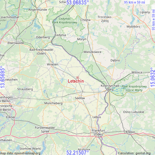
Letschin GPS coordinates[2]
52° 38' 37.644" North, 14° 21' 36.252" East
| Map corner | latitude | longitude |
|---|---|---|
| Upper-left | 53.06835°, | 13.65695° |
| Center: | 52.64379°, | 14.36007° |
| Lower-right: | 52.21507°, | 15.0632° |
| Map W x H: | 94.9×94.9 km | = 59×59mi |
| max Lat: | 55.01917° ⇑20.8% North |
| Letschin: | 52.64379° |
| min Lat: | ⇓79.2% South 47.40724° |
| min Long | Letschin | max Long |
| 5.92978° | 14.36007° | 14.98853° |
| W 99%⇐ | ⇒1% E |
Elevation
Elevation of Letschin is 9 m = 30 ft, and this is 240.1 m = 788 ft below average elevation for this country.
| Max E: |
1256 m = 4121 ft | 94.8% |
| Avg. | 249.1 m = 817 ft | |
| Letschin | 9 m = 30 ft | |
Min E: |
-5 m = -16 ft | 5.2% |
See also: Germany elevation on elevation.city.
Geographical zone
Letschin is located in North temperate zone (between Tropic of Cancer and the Arctic Circle). Distance of this North polar circle is 1547.7 km =961.7 mi to North.| Distance of | km | miles | from Letschin |
|---|---|---|---|
| North Pole | 4153.6 | 2580.9 | to North |
| Arctic Circle | 1547.7 | 961.7 | to North |
| Tropic Cancer | 3247.5 | 2017.9 | to South |
| Equator | 5853.4 | 3637.1 | to South |


Nearby cities:
15 places around Letschin: (largest is in red/bold)
• Alt Tucheband
15.7 km =9.8 mi,  139°
139°
• Bliesdorf
14.6 km =9.1 mi,  292°
292°
• Buckow
21.1 km =13.1 mi,  245°
245°
• Golzow
11.9 km =7.4 mi,  130°
130°
• Gorgast
15.2 km =9.4 mi,  123°
123°
• Kietz
18.7 km =11.6 mi, 117°
• Lietzen
19.4 km =12.1 mi,  183°
183°
• Manschnow
16.7 km =10.4 mi, 128°
• Müncheberg
21.4 km =13.3 mi,  224°
224°
• Neuhardenberg
9.8 km =6.1 mi,  237°
237°
• Neulewin
10.5 km =6.5 mi,  328°
328°
• Neutrebbin
9.2 km =5.7 mi,  284°
284°
• Seelow
12.3 km =7.6 mi,  173°
173°
• Wriezen
17.5 km =10.9 mi,  299°
299°
• Zechin
7.4 km =4.6 mi, 122°
Sources, notices
• [Note1] Compared only with cities in Germany existing in our database
• [Src1] Map data: © OpenStreetMap contributors (CC-BY-SA)
• [Src2] Other city data from geonames.org with taken over terms of usage.
• [Src3] Geographical zone / Annual Mean Temperature by Robert A. Rohde @ Wikipedia
