Müncheberg geodata
Müncheberg (Brandenburg) is a populated place; located in Germany in Europe/Berlin (GMT+2) time zone. With population of 7,214 people, there are 2136 cities with bigger population in this country. Compared to other cities in Germany, 77.5% of cities are located further ↓South; 98.4% of cities are located further ←West and 75.8% of cities have higher elevation than Müncheberg. Note1
Administrative division(s):
- Level 1: Brandenburg
- Level 3: Landkreis Märkisch-Oderland
- Level 4: Müncheberg


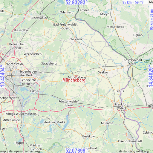
Müncheberg GPS coordinates[2]
52° 30' 25.344" North, 14° 8' 13.776" East
| Map corner | latitude | longitude |
|---|---|---|
| Upper-left | 52.93293°, | 13.43404° |
| Center: | 52.50704°, | 14.13716° |
| Lower-right: | 52.07699°, | 14.84029° |
| Map W x H: | 95.2×95.2 km | = 59.2×59.2mi |
| max Lat: | 55.01917° ⇑22.5% North |
| Müncheberg: | 52.50704° |
| min Lat: | ⇓77.5% South 47.40724° |
| min Long | Müncheberg | max Long |
| 5.92978° | 14.13716° | 14.98853° |
| W 98.4%⇐ | ⇒1.6% E |
Elevation
Elevation of Müncheberg is 60 m = 197 ft, and this is 189.1 m = 620 ft below average elevation for this country.
| Max E: |
1256 m = 4121 ft | 75.8% |
| Avg. | 249.1 m = 817 ft | |
| Müncheberg | 60 m = 197 ft | |
Min E: |
-5 m = -16 ft | 24.2% |
See also: Germany elevation on elevation.city.
Geographical zone
Müncheberg is located in North temperate zone (between Tropic of Cancer and the Arctic Circle). Distance of this North polar circle is 1562.9 km =971.1 mi to North.| Distance of | km | miles | from Müncheberg |
|---|---|---|---|
| North Pole | 4168.8 | 2590.4 | to North |
| Arctic Circle | 1562.9 | 971.1 | to North |
| Tropic Cancer | 3232.3 | 2008.5 | to South |
| Equator | 5838.2 | 3627.7 | to South |


Nearby cities:
15 places around Müncheberg: (largest is in red/bold)
• Berkenbrück
17.5 km =10.9 mi,  177°
177°
• Briesen
20.5 km =12.7 mi,  152°
152°
• Buckow
7.8 km =4.8 mi,  327°
327°
• Falkenhagen
14.7 km =9.1 mi,  123°
123°
• Fürstenwalde
17.1 km =10.6 mi,  197°
197°
• Langewahl
19.5 km =12.1 mi,  187°
187°
• Lietzen
14.3 km =8.9 mi,  106°
106°
• Neuhardenberg
12 km =7.5 mi,  34°
34°
• Neutrebbin
18.6 km =11.6 mi,  19°
19°
• Prötzel
17.6 km =10.9 mi, 325°
• Rehfelde
15.7 km =9.8 mi,  281°
281°
• Seelow
16.8 km =10.4 mi,  79°
79°
• Steinhöfel
12.1 km =7.5 mi,  170°
170°
• Strausberg
18.7 km =11.6 mi,  295°
295°
• Waldsieversdorf
6 km =3.7 mi,  310°
310°
Sources, notices
• [Note1] Compared only with cities in Germany existing in our database
• [Src1] Map data: © OpenStreetMap contributors (CC-BY-SA)
• [Src2] Other city data from geonames.org with taken over terms of usage.
• [Src3] Geographical zone / Annual Mean Temperature by Robert A. Rohde @ Wikipedia
