Lebrade geodata
Lebrade (Schleswig-Holstein) is a seat of a fourth-order administrative division; located in Germany in Europe/Berlin (GMT+2) time zone. With population of 640 people, there are 8600 cities with bigger population in this country. Compared to other cities in Germany, 95.3% of cities are located further ↓South; 57.3% of cities are located further ←West and 85.8% of cities have higher elevation than Lebrade. Note1


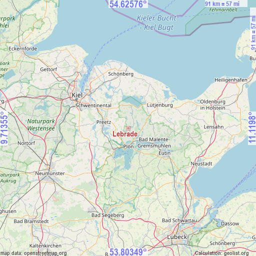
Lebrade GPS coordinates[2]
54° 13' 0.012" North, 10° 25' 0.012" East
| Map corner | latitude | longitude |
|---|---|---|
| Upper-left | 54.62576°, | 9.71355° |
| Center: | 54.21667°, | 10.41667° |
| Lower-right: | 53.80349°, | 11.1198° |
| Map W x H: | 91.4×91.4 km | = 56.8×56.8mi |
| max Lat: | 55.01917° ⇑4.7% North |
| Lebrade: | 54.21667° |
| min Lat: | ⇓95.3% South 47.40724° |
| min Long | Lebrade | max Long |
| 5.92978° | 10.41667° | 14.98853° |
| W 57.3%⇐ | ⇒42.7% E |
Elevation
Elevation of Lebrade is 33 m = 108 ft, and this is 216.1 m = 709 ft below average elevation for this country.
| Max E: |
1256 m = 4121 ft | 85.8% |
| Avg. | 249.1 m = 817 ft | |
| Lebrade | 33 m = 108 ft | |
Min E: |
-5 m = -16 ft | 14.2% |
See also: Germany elevation on elevation.city.
Geographical zone
Lebrade is located in North temperate zone (between Tropic of Cancer and the Arctic Circle). Distance of this North polar circle is 1372.8 km =853 mi to North.| Distance of | km | miles | from Lebrade |
|---|---|---|---|
| North Pole | 3978.7 | 2472.2 | to North |
| Arctic Circle | 1372.8 | 853 | to North |
| Tropic Cancer | 3422.4 | 2126.6 | to South |
| Equator | 6028.3 | 3745.8 | to South |


Nearby cities:
15 places around Lebrade: (largest is in red/bold)
• Ascheberg
8.7 km =5.4 mi,  212°
212°
• Bösdorf
8.6 km =5.3 mi,  149°
149°
• Dannau
8.6 km =5.3 mi,  71°
71°
• Dörnick
6.4 km =4 mi, 210°
• Grebin
5.7 km =3.5 mi,  108°
108°
• Lammershagen
7.7 km =4.8 mi,  16°
16°
• Lehmkuhlen
3.7 km =2.3 mi,  299°
299°
• Martensrade
7.5 km =4.7 mi,  351°
351°
• Mucheln
3.9 km =2.4 mi, 16°
• Plön
6 km =3.7 mi,  175°
175°
• Rantzau
7.5 km =4.7 mi,  60°
60°
• Rathjensdorf
3.9 km =2.4 mi,  163°
163°
• Schellhorn
8.1 km =5 mi,  280°
280°
• Selent
8.1 km =5 mi,  4°
4°
• Wittmoldt
6.4 km =4 mi, 210°
Sources, notices
• [Note1] Compared only with cities in Germany existing in our database
• [Src1] Map data: © OpenStreetMap contributors (CC-BY-SA)
• [Src2] Other city data from geonames.org with taken over terms of usage.
• [Src3] Geographical zone / Annual Mean Temperature by Robert A. Rohde @ Wikipedia
