Dannau geodata
Dannau (Schleswig-Holstein) is a seat of a fourth-order administrative division; located in Germany in Europe/Berlin (GMT+2) time zone. With population of 682 people, there are 8408 cities with bigger population in this country. Compared to other cities in Germany, 95.7% of cities are located further ↓South; 59.7% of cities are located further ←West and 83.7% of cities have higher elevation than Dannau. Note1


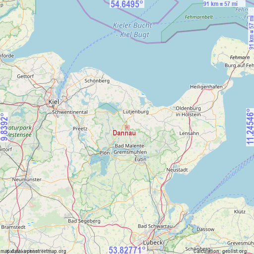
Dannau GPS coordinates[2]
54° 14' 26.34" North, 10° 32' 32.388" East
| Map corner | latitude | longitude |
|---|---|---|
| Upper-left | 54.6495°, | 9.8392° |
| Center: | 54.24065°, | 10.54233° |
| Lower-right: | 53.82771°, | 11.24546° |
| Map W x H: | 91.4×91.4 km | = 56.8×56.8mi |
| max Lat: | 55.01917° ⇑4.3% North |
| Dannau: | 54.24065° |
| min Lat: | ⇓95.7% South 47.40724° |
| min Long | Dannau | max Long |
| 5.92978° | 10.54233° | 14.98853° |
| W 59.7%⇐ | ⇒40.3% E |
Elevation
Elevation of Dannau is 38 m = 125 ft, and this is 211.1 m = 693 ft below average elevation for this country.
| Max E: |
1256 m = 4121 ft | 83.7% |
| Avg. | 249.1 m = 817 ft | |
| Dannau | 38 m = 125 ft | |
Min E: |
-5 m = -16 ft | 16.3% |
See also: Germany elevation on elevation.city.
Geographical zone
Dannau is located in North temperate zone (between Tropic of Cancer and the Arctic Circle). Distance of this North polar circle is 1370.2 km =851.4 mi to North.| Distance of | km | miles | from Dannau |
|---|---|---|---|
| North Pole | 3976.1 | 2470.6 | to North |
| Arctic Circle | 1370.2 | 851.4 | to North |
| Tropic Cancer | 3425.1 | 2128.3 | to South |
| Equator | 6031 | 3747.5 | to South |


Nearby cities:
15 places around Dannau: (largest is in red/bold)
• Blekendorf
8.8 km =5.5 mi,  58°
58°
• Giekau
8.6 km =5.3 mi,  348°
348°
• Grebin
5.3 km =3.3 mi,  211°
211°
• Helmstorf
6 km =3.7 mi,  38°
38°
• Högsdorf
4.9 km =3 mi,  77°
77°
• Klamp
6.6 km =4.1 mi, 354°
• Kletkamp
6 km =3.7 mi, 80°
• Lammershagen
7.6 km =4.7 mi,  308°
308°
• Lebrade
8.6 km =5.3 mi,  251°
251°
• Lütjenburg
6.5 km =4 mi,  28°
28°
• Malente
7.7 km =4.8 mi,  171°
171°
• Mucheln
7.2 km =4.5 mi,  278°
278°
• Neukirchen
3 km =1.9 mi, 165°
• Rantzau
2 km =1.2 mi,  301°
301°
• Selent
9.2 km =5.7 mi, 305°
Sources, notices
• [Note1] Compared only with cities in Germany existing in our database
• [Src1] Map data: © OpenStreetMap contributors (CC-BY-SA)
• [Src2] Other city data from geonames.org with taken over terms of usage.
• [Src3] Geographical zone / Annual Mean Temperature by Robert A. Rohde @ Wikipedia
