Dörnick geodata
Dörnick (Schleswig-Holstein) is a seat of a fourth-order administrative division; located in Germany in Europe/Berlin (GMT+2) time zone. With population of 282 people, there are 10129 cities with bigger population in this country. Compared to other cities in Germany, 94.6% of cities are located further ↓South; 56.6% of cities are located further ←West and 90.5% of cities have higher elevation than Dörnick. Note1


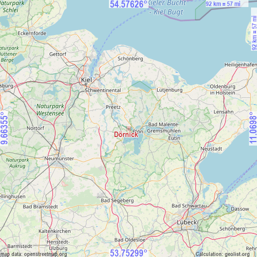
Dörnick GPS coordinates[2]
54° 10' 0.012" North, 10° 22' 0.012" East
| Map corner | latitude | longitude |
|---|---|---|
| Upper-left | 54.57626°, | 9.66355° |
| Center: | 54.16667°, | 10.36667° |
| Lower-right: | 53.75299°, | 11.0698° |
| Map W x H: | 91.5×91.5 km | = 56.9×56.9mi |
| max Lat: | 55.01917° ⇑5.4% North |
| Dörnick: | 54.16667° |
| min Lat: | ⇓94.6% South 47.40724° |
| min Long | Dörnick | max Long |
| 5.92978° | 10.36667° | 14.98853° |
| W 56.6%⇐ | ⇒43.4% E |
Elevation
Elevation of Dörnick is 20 m = 66 ft, and this is 229.1 m = 752 ft below average elevation for this country.
| Max E: |
1256 m = 4121 ft | 90.5% |
| Avg. | 249.1 m = 817 ft | |
| Dörnick | 20 m = 66 ft | |
Min E: |
-5 m = -16 ft | 9.5% |
See also: Germany elevation on elevation.city.
Geographical zone
Dörnick is located in North temperate zone (between Tropic of Cancer and the Arctic Circle). Distance of this North polar circle is 1378.4 km =856.5 mi to North.| Distance of | km | miles | from Dörnick |
|---|---|---|---|
| North Pole | 3984.3 | 2475.7 | to North |
| Arctic Circle | 1378.4 | 856.5 | to North |
| Tropic Cancer | 3416.9 | 2123.2 | to South |
| Equator | 6022.8 | 3742.4 | to South |


Nearby cities:
15 places around Dörnick: (largest is in red/bold)
• Ascheberg
2.3 km =1.4 mi,  217°
217°
• Bosau
8.9 km =5.5 mi,  149°
149°
• Bösdorf
7.8 km =4.8 mi,  103°
103°
• Dersau
5.8 km =3.6 mi,  201°
201°
• Kalübbe
7.8 km =4.8 mi, 224°
• Kühren
7.8 km =4.8 mi,  297°
297°
• Lebrade
6.4 km =4 mi,  30°
30°
• Lehmkuhlen
7.4 km =4.6 mi,  0°
0°
• Nehmten
7.7 km =4.8 mi,  163°
163°
• Plön
3.7 km =2.3 mi, 97°
• Rathjensdorf
4.7 km =2.9 mi,  66°
66°
• Schellhorn
8.4 km =5.2 mi,  325°
325°
• Stocksee
8.7 km =5.4 mi,  190°
190°
• Wahlstorf (Dorf)
4.9 km =3 mi,  285°
285°
• Wittmoldt
0 km =0 mi, 0°
Sources, notices
• [Note1] Compared only with cities in Germany existing in our database
• [Src1] Map data: © OpenStreetMap contributors (CC-BY-SA)
• [Src2] Other city data from geonames.org with taken over terms of usage.
• [Src3] Geographical zone / Annual Mean Temperature by Robert A. Rohde @ Wikipedia
