Schellhorn geodata
Schellhorn (Schleswig-Holstein) is a seat of a fourth-order administrative division; located in Germany in Europe/Berlin (GMT+2) time zone. With population of 1,714 people, there are 5491 cities with bigger population in this country. Compared to other cities in Germany, 95.5% of cities are located further ↓South; 55.2% of cities are located further ←West and 83.7% of cities have higher elevation than Schellhorn. Note1


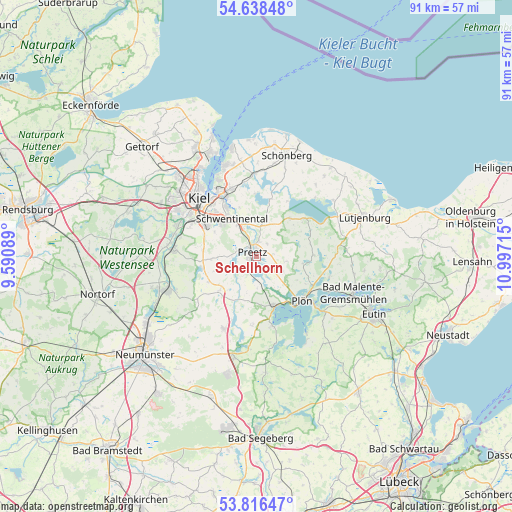
Schellhorn GPS coordinates[2]
54° 13' 46.272" North, 10° 17' 38.472" East
| Map corner | latitude | longitude |
|---|---|---|
| Upper-left | 54.63848°, | 9.59089° |
| Center: | 54.22952°, | 10.29402° |
| Lower-right: | 53.81647°, | 10.99715° |
| Map W x H: | 91.4×91.4 km | = 56.8×56.8mi |
| max Lat: | 55.01917° ⇑4.5% North |
| Schellhorn: | 54.22952° |
| min Lat: | ⇓95.5% South 47.40724° |
| min Long | Schellhorn | max Long |
| 5.92978° | 10.29402° | 14.98853° |
| W 55.2%⇐ | ⇒44.8% E |
Elevation
Elevation of Schellhorn is 38 m = 125 ft, and this is 211.1 m = 693 ft below average elevation for this country.
| Max E: |
1256 m = 4121 ft | 83.7% |
| Avg. | 249.1 m = 817 ft | |
| Schellhorn | 38 m = 125 ft | |
Min E: |
-5 m = -16 ft | 16.3% |
See also: Germany elevation on elevation.city.
Geographical zone
Schellhorn is located in North temperate zone (between Tropic of Cancer and the Arctic Circle). Distance of this North polar circle is 1371.4 km =852.1 mi to North.| Distance of | km | miles | from Schellhorn |
|---|---|---|---|
| North Pole | 3977.3 | 2471.4 | to North |
| Arctic Circle | 1371.4 | 852.1 | to North |
| Tropic Cancer | 3423.8 | 2127.5 | to South |
| Equator | 6029.8 | 3746.7 | to South |


Nearby cities:
15 places around Schellhorn: (largest is in red/bold)
• Barmissen
7.9 km =4.9 mi,  245°
245°
• Dörnick
8.4 km =5.2 mi,  145°
145°
• Großbarkau
8.3 km =5.2 mi,  272°
272°
• Honigsee
7.2 km =4.5 mi, 273°
• Kühren
4.1 km =2.5 mi,  213°
213°
• Lebrade
8.1 km =5 mi,  100°
100°
• Lehmkuhlen
4.7 km =2.9 mi,  84°
84°
• Löptin
7.2 km =4.5 mi,  224°
224°
• Pohnsdorf
3.1 km =1.9 mi,  290°
290°
• Postfeld
5.7 km =3.5 mi, 248°
• Preetz
1.2 km =0.7 mi,  302°
302°
• Raisdorf
6.5 km =4 mi,  333°
333°
• Rastorf
4.2 km =2.6 mi,  350°
350°
• Wahlstorf (Dorf)
5.7 km =3.5 mi,  179°
179°
• Wittmoldt
8.4 km =5.2 mi, 145°
Sources, notices
• [Note1] Compared only with cities in Germany existing in our database
• [Src1] Map data: © OpenStreetMap contributors (CC-BY-SA)
• [Src2] Other city data from geonames.org with taken over terms of usage.
• [Src3] Geographical zone / Annual Mean Temperature by Robert A. Rohde @ Wikipedia
