Lauben geodata
Lauben (Bavaria) is a seat of a fourth-order administrative division; located in Germany in Europe/Berlin (GMT+2) time zone. With population of 1,361 people, there are 6161 cities with bigger population in this country. Compared to other cities in Germany, 94.7% of cities are located further ↑North; 55.2% of cities are located further ←West and 94.9% of cities have lower elevation than Lauben. Note1
Administrative division(s):
- Level 1: Bavaria
- Level 2: Swabia
- Level 3: Landkreis Unterallgäu
- Level 4: Lauben


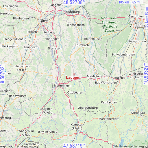
Lauben GPS coordinates[2]
48° 3' 33.408" North, 10° 17' 24.504" East
| Map corner | latitude | longitude |
|---|---|---|
| Upper-left | 48.52708°, | 9.58702° |
| Center: | 48.05928°, | 10.29014° |
| Lower-right: | 47.58719°, | 10.99327° |
| Map W x H: | 104.5×104.5 km | = 64.9×64.9mi |
| max Lat: | 55.01917° ⇑94.7% North |
| Lauben: | 48.05928° |
| min Lat: | ⇓5.3% South 47.40724° |
| min Long | Lauben | max Long |
| 5.92978° | 10.29014° | 14.98853° |
| W 55.2%⇐ | ⇒44.8% E |
Elevation
Elevation of Lauben is 596 m = 1955 ft, and this is 346.9 m = 1138 ft above average elevation for this country.
| Max E: |
1256 m = 4121 ft | 5.1% |
| Lauben | 596 m 1955 ft | |
| Avg. | 249.1 m = 817 ft | |
Min E: |
-5 m = -16 ft | 94.9% |
See also: Germany elevation on elevation.city.
Geographical zone
Lauben is located in North temperate zone (between Tropic of Cancer and the Arctic Circle). Distance of this North polar circle is 2057.5 km =1278.5 mi to North.| Distance of | km | miles | from Lauben |
|---|---|---|---|
| North Pole | 4663.4 | 2897.7 | to North |
| Arctic Circle | 2057.5 | 1278.5 | to North |
| Tropic Cancer | 2737.8 | 1701.2 | to South |
| Equator | 5343.7 | 3320.4 | to South |


Nearby cities:
15 places around Lauben: (largest is in red/bold)
• Babenhausen
9.9 km =6.2 mi,  343°
343°
• Boos
7.3 km =4.5 mi,  284°
284°
• Egg an der Günz
3.1 km =1.9 mi,  352°
352°
• Eisenburg
7.9 km =4.9 mi,  230°
230°
• Erkheim
4.2 km =2.6 mi,  125°
125°
• Holzgünz
4.5 km =2.8 mi,  211°
211°
• Memmingerberg
9.4 km =5.8 mi, 212°
• Niederrieden
7.9 km =4.9 mi,  268°
268°
• Oberschönegg
5.5 km =3.4 mi,  6°
6°
• Sontheim
7.5 km =4.7 mi,  140°
140°
• Trunkelsberg
8.6 km =5.3 mi,  219°
219°
• Ungerhausen
6.2 km =3.9 mi,  196°
196°
• Wald
9.7 km =6 mi,  175°
175°
• Westerheim
4.8 km =3 mi,  171°
171°
• Winterrieden
8.4 km =5.2 mi,  325°
325°
Sources, notices
• [Note1] Compared only with cities in Germany existing in our database
• [Src1] Map data: © OpenStreetMap contributors (CC-BY-SA)
• [Src2] Other city data from geonames.org with taken over terms of usage.
• [Src3] Geographical zone / Annual Mean Temperature by Robert A. Rohde @ Wikipedia
