Babenhausen geodata
Babenhausen (Bavaria) is a populated place; located in Germany in Europe/Berlin (GMT+2) time zone. With population of 5,342 people, there are 2685 cities with bigger population in this country. Compared to other cities in Germany, 93.5% of cities are located further ↑North; 54.5% of cities are located further ←West and 93% of cities have lower elevation than Babenhausen. Note1
Administrative division(s):
- Level 1: Bavaria
- Level 2: Swabia
- Level 3: Landkreis Unterallgäu
- Level 4: Babenhausen, Markt


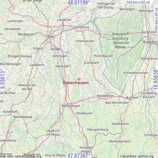
Babenhausen GPS coordinates[2]
48° 8' 41.892" North, 10° 15' 11.7" East
| Map corner | latitude | longitude |
|---|---|---|
| Upper-left | 48.61199°, | 9.55013° |
| Center: | 48.14497°, | 10.25325° |
| Lower-right: | 47.67367°, | 10.95638° |
| Map W x H: | 104.3×104.3 km | = 64.8×64.8mi |
| max Lat: | 55.01917° ⇑93.5% North |
| Babenhausen: | 48.14497° |
| min Lat: | ⇓6.5% South 47.40724° |
| min Long | Babenhausen | max Long |
| 5.92978° | 10.25325° | 14.98853° |
| W 54.5%⇐ | ⇒45.5% E |
Elevation
Elevation of Babenhausen is 557 m = 1827 ft, and this is 307.9 m = 1010 ft above average elevation for this country.
| Max E: |
1256 m = 4121 ft | 7% |
| Babenhausen | 557 m 1827 ft | |
| Avg. | 249.1 m = 817 ft | |
Min E: |
-5 m = -16 ft | 93% |
See also: Germany elevation on elevation.city.
Geographical zone
Babenhausen is located in North temperate zone (between Tropic of Cancer and the Arctic Circle). Distance of this North polar circle is 2048 km =1272.6 mi to North.| Distance of | km | miles | from Babenhausen |
|---|---|---|---|
| North Pole | 4653.8 | 2891.7 | to North |
| Arctic Circle | 2048 | 1272.6 | to North |
| Tropic Cancer | 2747.3 | 1707.1 | to South |
| Equator | 5353.2 | 3326.3 | to South |


Nearby cities:
15 places around Babenhausen: (largest is in red/bold)
• Altenstadt
10.4 km =6.5 mi,  279°
279°
• Boos
8.9 km =5.5 mi,  209°
209°
• Ebershausen
8.2 km =5.1 mi,  34°
34°
• Egg an der Günz
6.8 km =4.2 mi,  159°
159°
• Kellmünz
9.6 km =6 mi,  254°
254°
• Kettershausen
4.4 km =2.7 mi,  13°
13°
• Kirchhaslach
4.3 km =2.7 mi,  81°
81°
• Lauben
9.9 km =6.2 mi, 163°
• Oberroth
5.9 km =3.7 mi,  305°
305°
• Oberschönegg
5.3 km =3.3 mi,  140°
140°
• Osterberg
6.4 km =4 mi,  274°
274°
• Pless
9.5 km =5.9 mi,  232°
232°
• Unterroth
8.3 km =5.2 mi, 312°
• Waltenhausen
9.7 km =6 mi,  58°
58°
• Winterrieden
3.3 km =2.1 mi,  217°
217°
Sources, notices
• [Note1] Compared only with cities in Germany existing in our database
• [Src1] Map data: © OpenStreetMap contributors (CC-BY-SA)
• [Src2] Other city data from geonames.org with taken over terms of usage.
• [Src3] Geographical zone / Annual Mean Temperature by Robert A. Rohde @ Wikipedia
