Sontheim geodata
Sontheim (Bavaria) is a seat of a fourth-order administrative division; located in Germany in Europe/Berlin (GMT+2) time zone. With population of 2,490 people, there are 4451 cities with bigger population in this country. Compared to other cities in Germany, 95.4% of cities are located further ↑North; 56.4% of cities are located further ←West and 95.8% of cities have lower elevation than Sontheim. Note1
Administrative division(s):
- Level 1: Bavaria
- Level 2: Swabia
- Level 3: Landkreis Unterallgäu
- Level 4: Sontheim


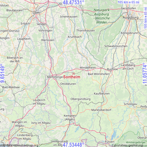
Sontheim GPS coordinates[2]
48° 0' 25.344" North, 10° 21' 16.596" East
| Map corner | latitude | longitude |
|---|---|---|
| Upper-left | 48.47531°, | 9.65149° |
| Center: | 48.00704°, | 10.35461° |
| Lower-right: | 47.53448°, | 11.05774° |
| Map W x H: | 104.6×104.6 km | = 65×65mi |
| max Lat: | 55.01917° ⇑95.4% North |
| Sontheim: | 48.00704° |
| min Lat: | ⇓4.6% South 47.40724° |
| min Long | Sontheim | max Long |
| 5.92978° | 10.35461° | 14.98853° |
| W 56.4%⇐ | ⇒43.6% E |
Elevation
Elevation of Sontheim is 620 m = 2034 ft, and this is 370.9 m = 1217 ft above average elevation for this country.
| Max E: |
1256 m = 4121 ft | 4.2% |
| Sontheim | 620 m 2034 ft | |
| Avg. | 249.1 m = 817 ft | |
Min E: |
-5 m = -16 ft | 95.8% |
See also: Germany elevation on elevation.city.
Geographical zone
Sontheim is located in North temperate zone (between Tropic of Cancer and the Arctic Circle). Distance of this North polar circle is 2063.3 km =1282.1 mi to North.| Distance of | km | miles | from Sontheim |
|---|---|---|---|
| North Pole | 4669.2 | 2901.3 | to North |
| Arctic Circle | 2063.3 | 1282.1 | to North |
| Tropic Cancer | 2732 | 1697.6 | to South |
| Equator | 5337.9 | 3316.8 | to South |


Nearby cities:
15 places around Sontheim: (largest is in red/bold)
• Egg an der Günz
10.3 km =6.4 mi,  329°
329°
• Erkheim
3.6 km =2.2 mi,  337°
337°
• Hawangen
7.9 km =4.9 mi,  235°
235°
• Holzgünz
7.4 km =4.6 mi,  285°
285°
• Lauben
7.5 km =4.7 mi,  320°
320°
• Markt Rettenbach
7.3 km =4.5 mi,  155°
155°
• Memmingerberg
10 km =6.2 mi,  257°
257°
• Oberrieden
10.5 km =6.5 mi,  30°
30°
• Ottobeuren
8.4 km =5.2 mi,  209°
209°
• Stetten
7 km =4.3 mi,  74°
74°
• Trunkelsberg
10.3 km =6.4 mi,  265°
265°
• Ungerhausen
6.5 km =4 mi, 268°
• Unteregg
9.5 km =5.9 mi,  118°
118°
• Wald
5.6 km =3.5 mi,  226°
226°
• Westerheim
4.2 km =2.6 mi,  284°
284°
Sources, notices
• [Note1] Compared only with cities in Germany existing in our database
• [Src1] Map data: © OpenStreetMap contributors (CC-BY-SA)
• [Src2] Other city data from geonames.org with taken over terms of usage.
• [Src3] Geographical zone / Annual Mean Temperature by Robert A. Rohde @ Wikipedia
