Langensendelbach geodata
Langensendelbach (Bavaria) is a seat of a fourth-order administrative division; located in Germany in Europe/Berlin (GMT+2) time zone. With population of 2,837 people, there are 4141 cities with bigger population in this country. Compared to other cities in Germany, 72.7% of cities are located further ↑North; 68% of cities are located further ←West and 60.9% of cities have lower elevation than Langensendelbach. Note1
Administrative division(s):
- Level 1: Bavaria
- Level 2: Upper Franconia
- Level 3: Landkreis Forchheim
- Level 4: Langensendelbach


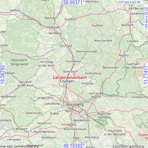
Langensendelbach GPS coordinates[2]
49° 38' 25.836" North, 11° 4' 15.744" East
| Map corner | latitude | longitude |
|---|---|---|
| Upper-left | 50.09371°, | 10.36792° |
| Center: | 49.64051°, | 11.07104° |
| Lower-right: | 49.18305°, | 11.77417° |
| Map W x H: | 101.3×101.3 km | = 62.9×62.9mi |
| max Lat: | 55.01917° ⇑72.7% North |
| Langensendelbach: | 49.64051° |
| min Lat: | ⇓27.3% South 47.40724° |
| min Long | Langensendelbac | max Long |
| 5.92978° | 11.07104° | 14.98853° |
| W 68%⇐ | ⇒32% E |
Elevation
Elevation of Langensendelbach is 295 m = 968 ft, and this is 45.9 m = 151 ft above average elevation for this country.
| Max E: |
1256 m = 4121 ft | 39.1% |
| Langensendelbach | 295 m 968 ft | |
| Avg. | 249.1 m = 817 ft | |
Min E: |
-5 m = -16 ft | 60.9% |
See also: Germany elevation on elevation.city.
Geographical zone
Langensendelbach is located in North temperate zone (between Tropic of Cancer and the Arctic Circle). Distance of this North polar circle is 1881.7 km =1169.2 mi to North.| Distance of | km | miles | from Langensendelbach |
|---|---|---|---|
| North Pole | 4487.6 | 2788.5 | to North |
| Arctic Circle | 1881.7 | 1169.2 | to North |
| Tropic Cancer | 2913.6 | 1810.4 | to South |
| Equator | 5519.5 | 3429.7 | to South |


Nearby cities:
15 places around Langensendelbach: (largest is in red/bold)
• Baiersdorf
3.2 km =2 mi,  307°
307°
• Bubenreuth
4.1 km =2.5 mi,  249°
249°
• Buckenhof
5.5 km =3.4 mi,  195°
195°
• Dormitz
5.8 km =3.6 mi,  144°
144°
• Effeltrich
2.6 km =1.6 mi,  37°
37°
• Hausen
6.1 km =3.8 mi,  332°
332°
• Hetzles
4.6 km =2.9 mi,  100°
100°
• Kunreuth
7 km =4.3 mi,  48°
48°
• Marloffstein
2.6 km =1.6 mi,  192°
192°
• Möhrendorf
5.2 km =3.2 mi,  261°
261°
• Neunkirchen am Brand
5.3 km =3.3 mi,  126°
126°
• Pinzberg
5.9 km =3.7 mi,  22°
22°
• Poxdorf
2.5 km =1.6 mi,  359°
359°
• Spardorf
3.7 km =2.3 mi, 197°
• Uttenreuth
4.9 km =3 mi,  179°
179°
Sources, notices
• [Note1] Compared only with cities in Germany existing in our database
• [Src1] Map data: © OpenStreetMap contributors (CC-BY-SA)
• [Src2] Other city data from geonames.org with taken over terms of usage.
• [Src3] Geographical zone / Annual Mean Temperature by Robert A. Rohde @ Wikipedia
