Möhrendorf geodata
Möhrendorf (Bavaria) is a seat of a fourth-order administrative division; located in Germany in Europe/Berlin (GMT+2) time zone. With population of 4,349 people, there are 3111 cities with bigger population in this country. Compared to other cities in Germany, 73% of cities are located further ↑North; 66.9% of cities are located further ←West and 57% of cities have lower elevation than Möhrendorf. Note1
Administrative division(s):
- Level 1: Bavaria
- Level 2: Regierungsbezirk Mittelfranken
- Level 3: Landkreis Erlangen-Höchstadt
- Level 4: Möhrendorf


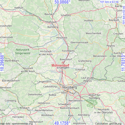
Möhrendorf GPS coordinates[2]
49° 37' 59.988" North, 11° 0' 0" East
| Map corner | latitude | longitude |
|---|---|---|
| Upper-left | 50.0866°, | 10.29688° |
| Center: | 49.63333°, | 11° |
| Lower-right: | 49.1758°, | 11.70313° |
| Map W x H: | 101.3×101.3 km | = 62.9×62.9mi |
| max Lat: | 55.01917° ⇑73% North |
| Möhrendorf: | 49.63333° |
| min Lat: | ⇓27% South 47.40724° |
| min Long | Möhrendorf | max Long |
| 5.92978° | 11° | 14.98853° |
| W 66.9%⇐ | ⇒33.1% E |
Elevation
Elevation of Möhrendorf is 272 m = 892 ft, and this is 22.9 m = 75 ft above average elevation for this country.
| Max E: |
1256 m = 4121 ft | 43% |
| Möhrendorf | 272 m 892 ft | |
| Avg. | 249.1 m = 817 ft | |
Min E: |
-5 m = -16 ft | 57% |
See also: Germany elevation on elevation.city.
Geographical zone
Möhrendorf is located in North temperate zone (between Tropic of Cancer and the Arctic Circle). Distance of this North polar circle is 1882.5 km =1169.7 mi to North.| Distance of | km | miles | from Möhrendorf |
|---|---|---|---|
| North Pole | 4488.4 | 2789 | to North |
| Arctic Circle | 1882.5 | 1169.7 | to North |
| Tropic Cancer | 2912.8 | 1809.9 | to South |
| Equator | 5518.7 | 3429.2 | to South |


Nearby cities:
15 places around Möhrendorf: (largest is in red/bold)
• Baiersdorf
3.8 km =2.4 mi,  43°
43°
• Bubenreuth
1.4 km =0.9 mi,  117°
117°
• Buckenhof
5.8 km =3.6 mi,  140°
140°
• Effeltrich
7.3 km =4.5 mi,  66°
66°
• Erlangen
4.7 km =2.9 mi,  173°
173°
• Hausen
6.7 km =4.2 mi,  20°
20°
• Hemhofen
7.3 km =4.5 mi,  319°
319°
• Heroldsbach
6.7 km =4.2 mi,  359°
359°
• Heßdorf
6.5 km =4 mi,  264°
264°
• Langensendelbach
5.2 km =3.2 mi,  81°
81°
• Marloffstein
4.9 km =3 mi,  110°
110°
• Poxdorf
6.1 km =3.8 mi,  56°
56°
• Röttenbach
6.3 km =3.9 mi,  302°
302°
• Spardorf
4.9 km =3 mi, 124°
• Uttenreuth
6.6 km =4.1 mi,  128°
128°
Sources, notices
• [Note1] Compared only with cities in Germany existing in our database
• [Src1] Map data: © OpenStreetMap contributors (CC-BY-SA)
• [Src2] Other city data from geonames.org with taken over terms of usage.
• [Src3] Geographical zone / Annual Mean Temperature by Robert A. Rohde @ Wikipedia
