Buckenhof geodata
Buckenhof (Bavaria) is a seat of a fourth-order administrative division; located in Germany in Europe/Berlin (GMT+2) time zone. With population of 3,296 people, there are 3756 cities with bigger population in this country. Compared to other cities in Germany, 73.9% of cities are located further ↑North; 67.7% of cities are located further ←West and 59.8% of cities have lower elevation than Buckenhof. Note1
Administrative division(s):
- Level 1: Bavaria
- Level 2: Regierungsbezirk Mittelfranken
- Level 3: Landkreis Erlangen-Höchstadt
- Level 4: Buckenhof


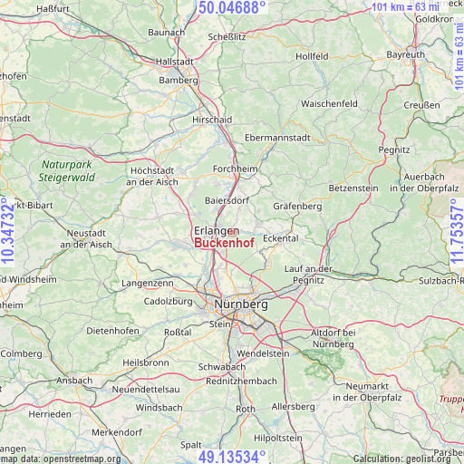
Buckenhof GPS coordinates[2]
49° 35' 35.664" North, 11° 3' 1.584" East
| Map corner | latitude | longitude |
|---|---|---|
| Upper-left | 50.04688°, | 10.34732° |
| Center: | 49.59324°, | 11.05044° |
| Lower-right: | 49.13534°, | 11.75357° |
| Map W x H: | 101.4×101.4 km | = 63×63mi |
| max Lat: | 55.01917° ⇑73.9% North |
| Buckenhof: | 49.59324° |
| min Lat: | ⇓26.1% South 47.40724° |
| min Long | Buckenhof | max Long |
| 5.92978° | 11.05044° | 14.98853° |
| W 67.7%⇐ | ⇒32.3% E |
Elevation
Elevation of Buckenhof is 289 m = 948 ft, and this is 39.9 m = 131 ft above average elevation for this country.
| Max E: |
1256 m = 4121 ft | 40.2% |
| Buckenhof | 289 m 948 ft | |
| Avg. | 249.1 m = 817 ft | |
Min E: |
-5 m = -16 ft | 59.8% |
See also: Germany elevation on elevation.city.
Geographical zone
Buckenhof is located in North temperate zone (between Tropic of Cancer and the Arctic Circle). Distance of this North polar circle is 1886.9 km =1172.5 mi to North.| Distance of | km | miles | from Buckenhof |
|---|---|---|---|
| North Pole | 4492.8 | 2791.7 | to North |
| Arctic Circle | 1886.9 | 1172.5 | to North |
| Tropic Cancer | 2908.3 | 1807.1 | to South |
| Equator | 5514.3 | 3426.4 | to South |


Nearby cities:
15 places around Buckenhof: (largest is in red/bold)
• Baiersdorf
7.3 km =4.5 mi,  351°
351°
• Bubenreuth
4.5 km =2.8 mi,  327°
327°
• Dormitz
4.9 km =3 mi,  83°
83°
• Effeltrich
8 km =5 mi,  22°
22°
• Erlangen
3.1 km =1.9 mi,  265°
265°
• Hetzles
7.5 km =4.7 mi,  53°
53°
• Kalchreuth
7.2 km =4.5 mi,  123°
123°
• Kleinsendelbach
7.7 km =4.8 mi,  88°
88°
• Langensendelbach
5.5 km =3.4 mi, 15°
• Marloffstein
2.9 km =1.8 mi, 18°
• Möhrendorf
5.8 km =3.6 mi,  320°
320°
• Neunkirchen am Brand
6.1 km =3.8 mi,  69°
69°
• Poxdorf
7.9 km =4.9 mi,  10°
10°
• Spardorf
1.7 km =1.1 mi, 12°
• Uttenreuth
1.6 km =1 mi, 76°
Sources, notices
• [Note1] Compared only with cities in Germany existing in our database
• [Src1] Map data: © OpenStreetMap contributors (CC-BY-SA)
• [Src2] Other city data from geonames.org with taken over terms of usage.
• [Src3] Geographical zone / Annual Mean Temperature by Robert A. Rohde @ Wikipedia
