Gerhardshofen geodata
Gerhardshofen (Bavaria) is a seat of a fourth-order administrative division; located in Germany in Europe/Berlin (GMT+2) time zone. With population of 2,510 people, there are 4427 cities with bigger population in this country. Compared to other cities in Germany, 73.1% of cities are located further ↑North; 62.4% of cities are located further ←West and 59.8% of cities have lower elevation than Gerhardshofen. Note1
Administrative division(s):
- Level 1: Bavaria
- Level 2: Regierungsbezirk Mittelfranken
- Level 3: Landkreis Neustadt an der Aisch-Bad Windsheim
- Level 4: Gerhardshofen


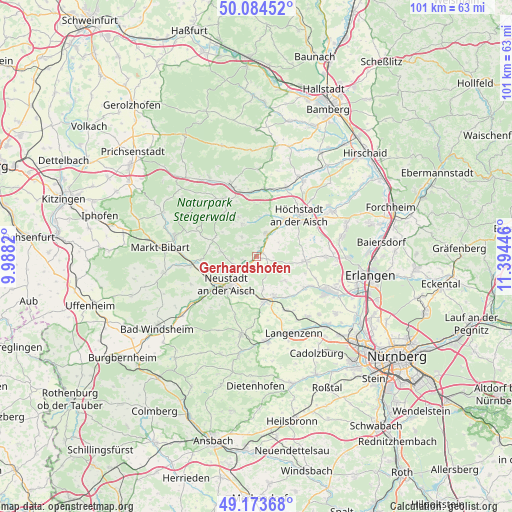
Gerhardshofen GPS coordinates[2]
49° 37' 52.428" North, 10° 41' 28.788" East
| Map corner | latitude | longitude |
|---|---|---|
| Upper-left | 50.08452°, | 9.9882° |
| Center: | 49.63123°, | 10.69133° |
| Lower-right: | 49.17368°, | 11.39446° |
| Map W x H: | 101.3×101.3 km | = 62.9×62.9mi |
| max Lat: | 55.01917° ⇑73.1% North |
| Gerhardshofen: | 49.63123° |
| min Lat: | ⇓26.9% South 47.40724° |
| min Long | Gerhardshofen | max Long |
| 5.92978° | 10.69133° | 14.98853° |
| W 62.4%⇐ | ⇒37.6% E |
Elevation
Elevation of Gerhardshofen is 289 m = 948 ft, and this is 39.9 m = 131 ft above average elevation for this country.
| Max E: |
1256 m = 4121 ft | 40.2% |
| Gerhardshofen | 289 m 948 ft | |
| Avg. | 249.1 m = 817 ft | |
Min E: |
-5 m = -16 ft | 59.8% |
See also: Germany elevation on elevation.city.
Geographical zone
Gerhardshofen is located in North temperate zone (between Tropic of Cancer and the Arctic Circle). Distance of this North polar circle is 1882.7 km =1169.9 mi to North.| Distance of | km | miles | from Gerhardshofen |
|---|---|---|---|
| North Pole | 4488.6 | 2789.1 | to North |
| Arctic Circle | 1882.7 | 1169.9 | to North |
| Tropic Cancer | 2912.6 | 1809.8 | to South |
| Equator | 5518.5 | 3429 | to South |


Nearby cities:
15 places around Gerhardshofen: (largest is in red/bold)
• Baudenbach
11.2 km =7 mi,  266°
266°
• Diespeck
5.4 km =3.4 mi,  230°
230°
• Emskirchen
8.9 km =5.5 mi,  169°
169°
• Gremsdorf
12.4 km =7.7 mi,  55°
55°
• Gutenstetten
4.5 km =2.8 mi,  248°
248°
• Hagenbüchach
12.2 km =7.6 mi,  153°
153°
• Höchstadt an der Aisch
12.1 km =7.5 mi,  46°
46°
• Lonnerstadt
9.3 km =5.8 mi,  35°
35°
• Münchsteinach
7 km =4.3 mi,  277°
277°
• Neustadt an der Aisch
8.1 km =5 mi, 225°
• Oberreichenbach
7.3 km =4.5 mi,  129°
129°
• Uehlfeld
4.9 km =3 mi,  25°
25°
• Vestenbergsgreuth
6.9 km =4.3 mi,  335°
335°
• Weisendorf
9.7 km =6 mi,  95°
95°
• Wilhelmsdorf
8.2 km =5.1 mi,  156°
156°
Sources, notices
• [Note1] Compared only with cities in Germany existing in our database
• [Src1] Map data: © OpenStreetMap contributors (CC-BY-SA)
• [Src2] Other city data from geonames.org with taken over terms of usage.
• [Src3] Geographical zone / Annual Mean Temperature by Robert A. Rohde @ Wikipedia
