Landsberg geodata
Landsberg (Saxony-Anhalt) is a populated place; located in Germany in Europe/Berlin (GMT+2) time zone. With population of 4,563 people, there are 3003 cities with bigger population in this country. Compared to other cities in Germany, 66.7% of cities are located further ↓South; 84% of cities are located further ←West and 65.4% of cities have higher elevation than Landsberg. Note1


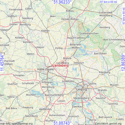
Landsberg GPS coordinates[2]
51° 31' 37.128" North, 12° 9' 38.736" East
| Map corner | latitude | longitude |
|---|---|---|
| Upper-left | 51.96233°, | 11.45764° |
| Center: | 51.52698°, | 12.16076° |
| Lower-right: | 51.08743°, | 12.86389° |
| Map W x H: | 97.3×97.3 km | = 60.5×60.5mi |
| max Lat: | 55.01917° ⇑33.3% North |
| Landsberg: | 51.52698° |
| min Lat: | ⇓66.7% South 47.40724° |
| min Long | Landsberg | max Long |
| 5.92978° | 12.16076° | 14.98853° |
| W 84%⇐ | ⇒16% E |
Elevation
Elevation of Landsberg is 118 m = 387 ft, and this is 131.1 m = 430 ft below average elevation for this country.
| Max E: |
1256 m = 4121 ft | 65.4% |
| Avg. | 249.1 m = 817 ft | |
| Landsberg | 118 m = 387 ft | |
Min E: |
-5 m = -16 ft | 34.6% |
See also: Germany elevation on elevation.city.
Geographical zone
Landsberg is located in North temperate zone (between Tropic of Cancer and the Arctic Circle). Distance of this North polar circle is 1671.9 km =1038.9 mi to North.| Distance of | km | miles | from Landsberg |
|---|---|---|---|
| North Pole | 4277.8 | 2658.1 | to North |
| Arctic Circle | 1671.9 | 1038.9 | to North |
| Tropic Cancer | 3123.3 | 1940.7 | to South |
| Equator | 5729.3 | 3560 | to South |


Nearby cities:
15 places around Landsberg: (largest is in red/bold)
• Brachstedt
9 km =5.6 mi,  302°
302°
• Braschwitz
7.1 km =4.4 mi,  266°
266°
• Brehna
5 km =3.1 mi,  46°
46°
• Glebitzsch
8 km =5 mi,  15°
15°
• Hohenthurm
4.5 km =2.8 mi,  257°
257°
• Niemberg
5.5 km =3.4 mi, 298°
• Peißen
7.6 km =4.7 mi,  249°
249°
• Queis
5.9 km =3.7 mi,  197°
197°
• Reußen
3.6 km =2.2 mi,  216°
216°
• Roitzsch
8.9 km =5.5 mi, 52°
• Schwerz
4.7 km =2.9 mi,  335°
335°
• Sietzsch
4.3 km =2.7 mi,  164°
164°
• Spickendorf
3.2 km =2 mi,  323°
323°
• Spören
8.7 km =5.4 mi, 342°
• Wiedemar
7.2 km =4.5 mi, 157°
Sources, notices
• [Note1] Compared only with cities in Germany existing in our database
• [Src1] Map data: © OpenStreetMap contributors (CC-BY-SA)
• [Src2] Other city data from geonames.org with taken over terms of usage.
• [Src3] Geographical zone / Annual Mean Temperature by Robert A. Rohde @ Wikipedia
