Schwerz geodata
Schwerz (Saxony-Anhalt) is a populated place; located in Germany in Europe/Berlin (GMT+2) time zone. With population of 564 people, there are 9006 cities with bigger population in this country. Compared to other cities in Germany, 67.1% of cities are located further ↓South; 83.6% of cities are located further ←West and 69.7% of cities have higher elevation than Schwerz. Note1


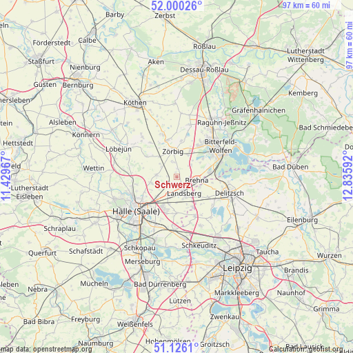
Schwerz GPS coordinates[2]
51° 33' 55.008" North, 12° 7' 58.044" East
| Map corner | latitude | longitude |
|---|---|---|
| Upper-left | 52.00026°, | 11.42967° |
| Center: | 51.56528°, | 12.13279° |
| Lower-right: | 51.1261°, | 12.83592° |
| Map W x H: | 97.2×97.2 km | = 60.4×60.4mi |
| max Lat: | 55.01917° ⇑32.9% North |
| Schwerz: | 51.56528° |
| min Lat: | ⇓67.1% South 47.40724° |
| min Long | Schwerz | max Long |
| 5.92978° | 12.13279° | 14.98853° |
| W 83.6%⇐ | ⇒16.4% E |
Elevation
Elevation of Schwerz is 93 m = 305 ft, and this is 156.1 m = 512 ft below average elevation for this country.
| Max E: |
1256 m = 4121 ft | 69.7% |
| Avg. | 249.1 m = 817 ft | |
| Schwerz | 93 m = 305 ft | |
Min E: |
-5 m = -16 ft | 30.3% |
See also: Germany elevation on elevation.city.
Geographical zone
Schwerz is located in North temperate zone (between Tropic of Cancer and the Arctic Circle). Distance of this North polar circle is 1667.7 km =1036.3 mi to North.| Distance of | km | miles | from Schwerz |
|---|---|---|---|
| North Pole | 4273.5 | 2655.4 | to North |
| Arctic Circle | 1667.7 | 1036.3 | to North |
| Tropic Cancer | 3127.6 | 1943.4 | to South |
| Equator | 5733.5 | 3562.6 | to South |


Nearby cities:
15 places around Schwerz: (largest is in red/bold)
• Brachstedt
5.7 km =3.5 mi,  276°
276°
• Braschwitz
7 km =4.3 mi,  227°
227°
• Brehna
5.6 km =3.5 mi,  98°
98°
• Glebitzsch
5.3 km =3.3 mi,  49°
49°
• Großzöberitz
6.8 km =4.2 mi,  28°
28°
• Hohenthurm
5.8 km =3.6 mi,  204°
204°
• Landsberg
4.7 km =2.9 mi,  155°
155°
• Niemberg
3.3 km =2.1 mi,  240°
240°
• Oppin
7.1 km =4.4 mi,  257°
257°
• Reußen
7.1 km =4.4 mi,  181°
181°
• Schrenz
4.9 km =3 mi,  300°
300°
• Spickendorf
1.6 km =1 mi, 179°
• Spören
4.1 km =2.5 mi,  350°
350°
• Stumsdorf
7.4 km =4.6 mi,  319°
319°
• Zörbig
7.2 km =4.5 mi, 351°
Sources, notices
• [Note1] Compared only with cities in Germany existing in our database
• [Src1] Map data: © OpenStreetMap contributors (CC-BY-SA)
• [Src2] Other city data from geonames.org with taken over terms of usage.
• [Src3] Geographical zone / Annual Mean Temperature by Robert A. Rohde @ Wikipedia
