Sietzsch geodata
Sietzsch (Saxony-Anhalt) is a populated place; located in Germany in Europe/Berlin (GMT+2) time zone. With population of 729 people, there are 8200 cities with bigger population in this country. Compared to other cities in Germany, 66.1% of cities are located further ↓South; 84.3% of cities are located further ←West and 67.1% of cities have higher elevation than Sietzsch. Note1


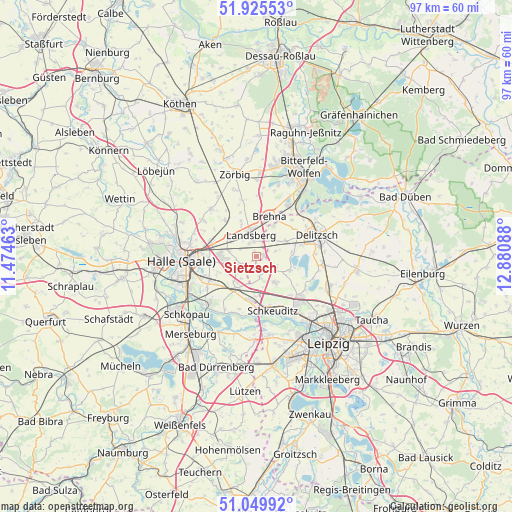
Sietzsch GPS coordinates[2]
51° 29' 23.388" North, 12° 10' 39.9" East
| Map corner | latitude | longitude |
|---|---|---|
| Upper-left | 51.92553°, | 11.47463° |
| Center: | 51.48983°, | 12.17775° |
| Lower-right: | 51.04992°, | 12.88088° |
| Map W x H: | 97.4×97.4 km | = 60.5×60.5mi |
| max Lat: | 55.01917° ⇑33.9% North |
| Sietzsch: | 51.48983° |
| min Lat: | ⇓66.1% South 47.40724° |
| min Long | Sietzsch | max Long |
| 5.92978° | 12.17775° | 14.98853° |
| W 84.3%⇐ | ⇒15.7% E |
Elevation
Elevation of Sietzsch is 107 m = 351 ft, and this is 142.1 m = 466 ft below average elevation for this country.
| Max E: |
1256 m = 4121 ft | 67.1% |
| Avg. | 249.1 m = 817 ft | |
| Sietzsch | 107 m = 351 ft | |
Min E: |
-5 m = -16 ft | 32.9% |
See also: Germany elevation on elevation.city.
Geographical zone
Sietzsch is located in North temperate zone (between Tropic of Cancer and the Arctic Circle). Distance of this North polar circle is 1676 km =1041.4 mi to North.| Distance of | km | miles | from Sietzsch |
|---|---|---|---|
| North Pole | 4281.9 | 2660.6 | to North |
| Arctic Circle | 1676 | 1041.4 | to North |
| Tropic Cancer | 3119.2 | 1938.2 | to South |
| Equator | 5725.1 | 3557.4 | to South |


Nearby cities:
15 places around Sietzsch: (largest is in red/bold)
• Braschwitz
9 km =5.6 mi,  294°
294°
• Brehna
7.9 km =4.9 mi,  17°
17°
• Dölbau
8.7 km =5.4 mi,  253°
253°
• Großkugel
8.4 km =5.2 mi,  195°
195°
• Gröbers
7.9 km =4.9 mi,  212°
212°
• Hohenthurm
6.4 km =4 mi,  299°
299°
• Landsberg
4.3 km =2.7 mi,  344°
344°
• Niemberg
9 km =5.6 mi,  318°
318°
• Peißen
8.5 km =5.3 mi,  279°
279°
• Queis
3.4 km =2.1 mi,  243°
243°
• Reußen
3.5 km =2.2 mi, 290°
• Schwerz
8.9 km =5.5 mi, 339°
• Spickendorf
7.4 km =4.6 mi, 335°
• Wiedemar
3 km =1.9 mi,  149°
149°
• Zwochau
6.9 km =4.3 mi,  114°
114°
Sources, notices
• [Note1] Compared only with cities in Germany existing in our database
• [Src1] Map data: © OpenStreetMap contributors (CC-BY-SA)
• [Src2] Other city data from geonames.org with taken over terms of usage.
• [Src3] Geographical zone / Annual Mean Temperature by Robert A. Rohde @ Wikipedia
