Lalendorf geodata
Lalendorf (Mecklenburg-Vorpommern) is a populated place; located in Germany in Europe/Berlin (GMT+2) time zone. With population of 2,506 people, there are 4436 cities with bigger population in this country. Compared to other cities in Germany, 89.5% of cities are located further ↓South; 86.9% of cities are located further ←West and 84.5% of cities have higher elevation than Lalendorf. Note1
Administrative division(s):
- Level 1: Mecklenburg-Vorpommern
- Level 3: Landkreis Rostock
- Level 4: Lalendorf


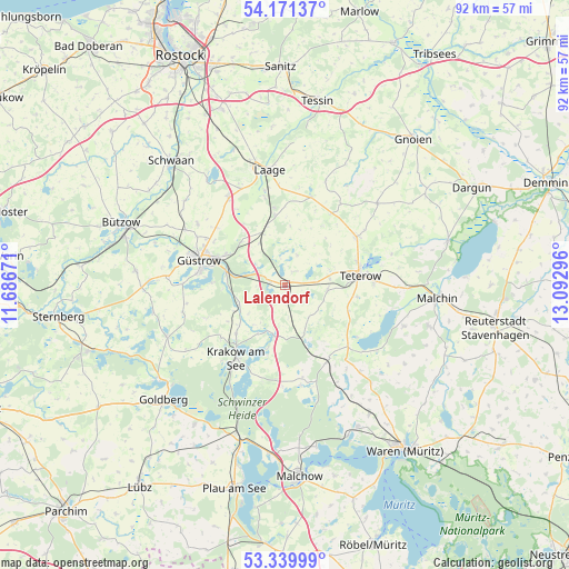
Lalendorf GPS coordinates[2]
53° 45' 27.864" North, 12° 23' 23.388" East
| Map corner | latitude | longitude |
|---|---|---|
| Upper-left | 54.17137°, | 11.68671° |
| Center: | 53.75774°, | 12.38983° |
| Lower-right: | 53.33999°, | 13.09296° |
| Map W x H: | 92.4×92.4 km | = 57.4×57.4mi |
| max Lat: | 55.01917° ⇑10.5% North |
| Lalendorf: | 53.75774° |
| min Lat: | ⇓89.5% South 47.40724° |
| min Long | Lalendorf | max Long |
| 5.92978° | 12.38983° | 14.98853° |
| W 86.9%⇐ | ⇒13.1% E |
Elevation
Elevation of Lalendorf is 36 m = 118 ft, and this is 213.1 m = 699 ft below average elevation for this country.
| Max E: |
1256 m = 4121 ft | 84.5% |
| Avg. | 249.1 m = 817 ft | |
| Lalendorf | 36 m = 118 ft | |
Min E: |
-5 m = -16 ft | 15.5% |
See also: Germany elevation on elevation.city.
Geographical zone
Lalendorf is located in North temperate zone (between Tropic of Cancer and the Arctic Circle). Distance of this North polar circle is 1423.9 km =884.8 mi to North.| Distance of | km | miles | from Lalendorf |
|---|---|---|---|
| North Pole | 4029.8 | 2504 | to North |
| Arctic Circle | 1423.9 | 884.8 | to North |
| Tropic Cancer | 3371.4 | 2094.9 | to South |
| Equator | 5977.3 | 3714.1 | to South |


Nearby cities:
15 places around Lalendorf: (largest is in red/bold)
• Diekhof
12.2 km =7.6 mi,  351°
351°
• Groß Roge
7.9 km =4.9 mi,  72°
72°
• Groß Wokern
6.8 km =4.2 mi,  96°
96°
• Hoppenrade
8.4 km =5.2 mi,  246°
246°
• Krakow am See
14.2 km =8.8 mi,  213°
213°
• Kuchelmiß
8.6 km =5.3 mi,  192°
192°
• Langhagen
8.5 km =5.3 mi,  158°
158°
• Lüdershagen
9.4 km =5.8 mi,  242°
242°
• Mühl Rosin
11.6 km =7.2 mi,  273°
273°
• Pampow
14.4 km =8.9 mi,  91°
91°
• Plaaz
10 km =6.2 mi,  342°
342°
• Tessenow
14.2 km =8.8 mi,  111°
111°
• Teterow
12.3 km =7.6 mi,  80°
80°
• Vollrathsruhe
14.2 km =8.8 mi,  152°
152°
• Wattmannshagen
2.3 km =1.4 mi,  29°
29°
Sources, notices
• [Note1] Compared only with cities in Germany existing in our database
• [Src1] Map data: © OpenStreetMap contributors (CC-BY-SA)
• [Src2] Other city data from geonames.org with taken over terms of usage.
• [Src3] Geographical zone / Annual Mean Temperature by Robert A. Rohde @ Wikipedia
