Teterow geodata
Teterow (Mecklenburg-Vorpommern) is a populated place; located in Germany in Europe/Berlin (GMT+2) time zone. With population of 9,544 people, there are 1697 cities with bigger population in this country. Compared to other cities in Germany, 89.7% of cities are located further ↓South; 88.6% of cities are located further ←West and 95.2% of cities have higher elevation than Teterow. Note1
Administrative division(s):
- Level 1: Mecklenburg-Vorpommern
- Level 3: Landkreis Rostock
- Level 4: Teterow


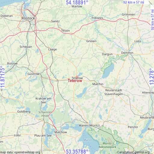
Teterow GPS coordinates[2]
53° 46' 31.62" North, 12° 34' 29.532" East
| Map corner | latitude | longitude |
|---|---|---|
| Upper-left | 54.18891°, | 11.87175° |
| Center: | 53.77545°, | 12.57487° |
| Lower-right: | 53.35788°, | 13.278° |
| Map W x H: | 92.4×92.4 km | = 57.4×57.4mi |
| max Lat: | 55.01917° ⇑10.3% North |
| Teterow: | 53.77545° |
| min Lat: | ⇓89.7% South 47.40724° |
| min Long | Teterow | max Long |
| 5.92978° | 12.57487° | 14.98853° |
| W 88.6%⇐ | ⇒11.4% E |
Elevation
Elevation of Teterow is 8 m = 26 ft, and this is 241.1 m = 791 ft below average elevation for this country.
| Max E: |
1256 m = 4121 ft | 95.2% |
| Avg. | 249.1 m = 817 ft | |
| Teterow | 8 m = 26 ft | |
Min E: |
-5 m = -16 ft | 4.8% |
See also: Germany elevation on elevation.city.
Geographical zone
Teterow is located in North temperate zone (between Tropic of Cancer and the Arctic Circle). Distance of this North polar circle is 1421.9 km =883.5 mi to North.| Distance of | km | miles | from Teterow |
|---|---|---|---|
| North Pole | 4027.8 | 2502.8 | to North |
| Arctic Circle | 1421.9 | 883.5 | to North |
| Tropic Cancer | 3373.4 | 2096.1 | to South |
| Equator | 5979.3 | 3715.4 | to South |


Nearby cities:
15 places around Teterow: (largest is in red/bold)
• Basedow
11.1 km =6.9 mi,  141°
141°
• Dahmen
12.7 km =7.9 mi,  178°
178°
• Gielow
14.2 km =8.8 mi,  127°
127°
• Groß Roge
4.6 km =2.9 mi,  274°
274°
• Groß Wokern
6 km =3.7 mi,  243°
243°
• Groß Wüstenfelde
11 km =6.8 mi,  352°
352°
• Jördenstorf
11.7 km =7.3 mi,  13°
13°
• Lalendorf
12.3 km =7.6 mi,  260°
260°
• Langhagen
13.5 km =8.4 mi,  222°
222°
• Lelkendorf
12.7 km =7.9 mi,  54°
54°
• Malchin
13.1 km =8.1 mi,  107°
107°
• Pampow
3.1 km =1.9 mi, 135°
• Remplin
8.4 km =5.2 mi, 106°
• Tessenow
7.3 km =4.5 mi,  172°
172°
• Wattmannshagen
11 km =6.8 mi, 270°
Sources, notices
• [Note1] Compared only with cities in Germany existing in our database
• [Src1] Map data: © OpenStreetMap contributors (CC-BY-SA)
• [Src2] Other city data from geonames.org with taken over terms of usage.
• [Src3] Geographical zone / Annual Mean Temperature by Robert A. Rohde @ Wikipedia
