Kronshagen geodata
Kronshagen (Schleswig-Holstein) is a seat of a fourth-order administrative division; located in Germany in Europe/Berlin (GMT+2) time zone. With population of 11,856 people, there are 1384 cities with bigger population in this country. Compared to other cities in Germany, 96.6% of cities are located further ↓South; 51.4% of cities are located further ←West and 89.3% of cities have higher elevation than Kronshagen. Note1
Administrative division(s):
- Level 1: Schleswig-Holstein
- Level 3: Kreis Rendsburg-Eckernförde
- Level 4: Kronshagen


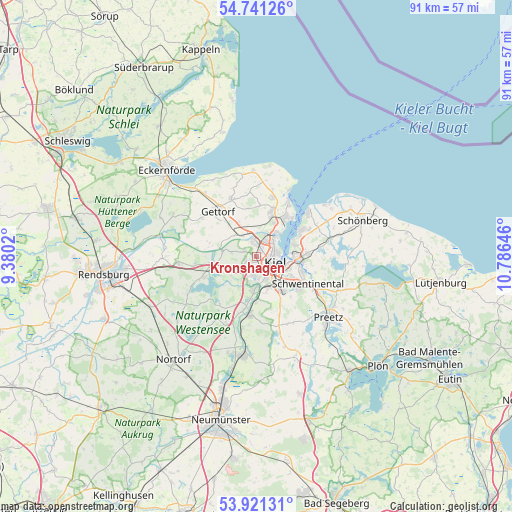
Kronshagen GPS coordinates[2]
54° 19' 59.988" North, 10° 4' 59.988" East
| Map corner | latitude | longitude |
|---|---|---|
| Upper-left | 54.74126°, | 9.3802° |
| Center: | 54.33333°, | 10.08333° |
| Lower-right: | 53.92131°, | 10.78646° |
| Map W x H: | 91.2×91.2 km | = 56.7×56.7mi |
| max Lat: | 55.01917° ⇑3.4% North |
| Kronshagen: | 54.33333° |
| min Lat: | ⇓96.6% South 47.40724° |
| min Long | Kronshagen | max Long |
| 5.92978° | 10.08333° | 14.98853° |
| W 51.4%⇐ | ⇒48.6% E |
Elevation
Elevation of Kronshagen is 23 m = 75 ft, and this is 226.1 m = 742 ft below average elevation for this country.
| Max E: |
1256 m = 4121 ft | 89.3% |
| Avg. | 249.1 m = 817 ft | |
| Kronshagen | 23 m = 75 ft | |
Min E: |
-5 m = -16 ft | 10.7% |
See also: Germany elevation on elevation.city.
Geographical zone
Kronshagen is located in North temperate zone (between Tropic of Cancer and the Arctic Circle). Distance of this North polar circle is 1359.9 km =845 mi to North.| Distance of | km | miles | from Kronshagen |
|---|---|---|---|
| North Pole | 3965.8 | 2464.2 | to North |
| Arctic Circle | 1359.9 | 845 | to North |
| Tropic Cancer | 3435.4 | 2134.7 | to South |
| Equator | 6041.3 | 3753.9 | to South |


Nearby cities:
15 places around Kronshagen: (largest is in red/bold)
• Achterwehr
7.9 km =4.9 mi,  253°
253°
• Altenholz
8.1 km =5 mi,  23°
23°
• Flintbek
9.3 km =5.8 mi,  186°
186°
• Heikendorf
8.4 km =5.2 mi,  63°
63°
• Kiel
3.6 km =2.2 mi,  111°
111°
• Klausdorf
8.9 km =5.5 mi, 107°
• Melsdorf
3.7 km =2.3 mi,  240°
240°
• Mielkendorf
6 km =3.7 mi,  201°
201°
• Molfsee
7.5 km =4.7 mi, 188°
• Mönkeberg
6.7 km =4.2 mi,  74°
74°
• Neuwittenbek
5.7 km =3.5 mi,  310°
310°
• Ottendorf
2.4 km =1.5 mi,  290°
290°
• Quarnbek
6.5 km =4 mi,  270°
270°
• Rodenbek
7 km =4.3 mi,  217°
217°
• Tüttendorf
9.2 km =5.7 mi,  323°
323°
Sources, notices
• [Note1] Compared only with cities in Germany existing in our database
• [Src1] Map data: © OpenStreetMap contributors (CC-BY-SA)
• [Src2] Other city data from geonames.org with taken over terms of usage.
• [Src3] Geographical zone / Annual Mean Temperature by Robert A. Rohde @ Wikipedia
