Heikendorf geodata
Heikendorf (Schleswig-Holstein) is a seat of a fourth-order administrative division; located in Germany in Europe/Berlin (GMT+2) time zone. With population of 8,056 people, there are 1947 cities with bigger population in this country. Compared to other cities in Germany, 97% of cities are located further ↓South; 53.3% of cities are located further ←West and 97.6% of cities have higher elevation than Heikendorf. Note1


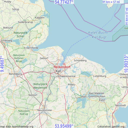
Heikendorf GPS coordinates[2]
54° 22' 0.012" North, 10° 12' 0" East
| Map corner | latitude | longitude |
|---|---|---|
| Upper-left | 54.77427°, | 9.49687° |
| Center: | 54.36667°, | 10.2° |
| Lower-right: | 53.95499°, | 10.90313° |
| Map W x H: | 91.1×91.1 km | = 56.6×56.6mi |
| max Lat: | 55.01917° ⇑3% North |
| Heikendorf: | 54.36667° |
| min Lat: | ⇓97% South 47.40724° |
| min Long | Heikendorf | max Long |
| 5.92978° | 10.2° | 14.98853° |
| W 53.3%⇐ | ⇒46.7% E |
Elevation
Elevation of Heikendorf is 3 m = 10 ft, and this is 246.1 m = 807 ft below average elevation for this country.
| Max E: |
1256 m = 4121 ft | 97.6% |
| Avg. | 249.1 m = 817 ft | |
| Heikendorf | 3 m = 10 ft | |
Min E: |
-5 m = -16 ft | 2.4% |
See also: Germany elevation on elevation.city.
Geographical zone
Heikendorf is located in North temperate zone (between Tropic of Cancer and the Arctic Circle). Distance of this North polar circle is 1356.2 km =842.7 mi to North.| Distance of | km | miles | from Heikendorf |
|---|---|---|---|
| North Pole | 3962.1 | 2461.9 | to North |
| Arctic Circle | 1356.2 | 842.7 | to North |
| Tropic Cancer | 3439.1 | 2137 | to South |
| Equator | 6045 | 3756.2 | to South |


Nearby cities:
15 places around Heikendorf: (largest is in red/bold)
• Altenholz
5.7 km =3.5 mi,  310°
310°
• Brodersdorf
3.7 km =2.3 mi,  60°
60°
• Dobersdorf
7.4 km =4.6 mi,  135°
135°
• Kiel
6.6 km =4.1 mi,  219°
219°
• Klausdorf
6.5 km =4 mi,  172°
172°
• Laboe
3.9 km =2.4 mi,  16°
16°
• Lutterbek
6.5 km =4 mi, 55°
• Mönkeberg
2.1 km =1.3 mi,  210°
210°
• Passade
7.6 km =4.7 mi,  90°
90°
• Prasdorf
6.7 km =4.2 mi,  74°
74°
• Probsteierhagen
5.7 km =3.5 mi,  95°
95°
• Schönkirchen
4.3 km =2.7 mi,  149°
149°
• Stein
7 km =4.3 mi,  37°
37°
• Strande
7.7 km =4.8 mi,  343°
343°
• Wendtorf
7.7 km =4.8 mi,  48°
48°
Sources, notices
• [Note1] Compared only with cities in Germany existing in our database
• [Src1] Map data: © OpenStreetMap contributors (CC-BY-SA)
• [Src2] Other city data from geonames.org with taken over terms of usage.
• [Src3] Geographical zone / Annual Mean Temperature by Robert A. Rohde @ Wikipedia
