Tüttendorf geodata
Tüttendorf (Schleswig-Holstein) is a seat of a fourth-order administrative division; located in Germany in Europe/Berlin (GMT+2) time zone. With population of 1,197 people, there are 6573 cities with bigger population in this country. Compared to other cities in Germany, 97.4% of cities are located further ↓South; 50% of cities are located further ←West and 90.9% of cities have higher elevation than Tüttendorf. Note1
Administrative division(s):
- Level 1: Schleswig-Holstein
- Level 3: Kreis Rendsburg-Eckernförde
- Level 4: Tüttendorf


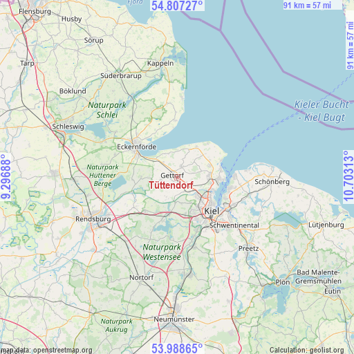
Tüttendorf GPS coordinates[2]
54° 24' 0" North, 10° 0' 0" East
| Map corner | latitude | longitude |
|---|---|---|
| Upper-left | 54.80727°, | 9.29688° |
| Center: | 54.4°, | 10° |
| Lower-right: | 53.98865°, | 10.70313° |
| Map W x H: | 91×91 km | = 56.5×56.5mi |
| max Lat: | 55.01917° ⇑2.6% North |
| Tüttendorf: | 54.4° |
| min Lat: | ⇓97.4% South 47.40724° |
| min Long | Tüttendorf | max Long |
| 5.92978° | 10° | 14.98853° |
| W 50%⇐ | ⇒50% E |
Elevation
Elevation of Tüttendorf is 19 m = 62 ft, and this is 230.1 m = 755 ft below average elevation for this country.
| Max E: |
1256 m = 4121 ft | 90.9% |
| Avg. | 249.1 m = 817 ft | |
| Tüttendorf | 19 m = 62 ft | |
Min E: |
-5 m = -16 ft | 9.1% |
See also: Germany elevation on elevation.city.
Geographical zone
Tüttendorf is located in North temperate zone (between Tropic of Cancer and the Arctic Circle). Distance of this North polar circle is 1352.5 km =840.4 mi to North.| Distance of | km | miles | from Tüttendorf |
|---|---|---|---|
| North Pole | 3958.3 | 2459.6 | to North |
| Arctic Circle | 1352.5 | 840.4 | to North |
| Tropic Cancer | 3442.8 | 2139.3 | to South |
| Equator | 6048.7 | 3758.5 | to South |


Nearby cities:
15 places around Tüttendorf: (largest is in red/bold)
• Altenhof
9.4 km =5.8 mi,  293°
293°
• Altenholz
8.6 km =5.3 mi,  90°
90°
• Dänischenhagen
8.7 km =5.4 mi,  69°
69°
• Felm
3.7 km =2.3 mi,  60°
60°
• Gettorf
1.1 km =0.7 mi,  270°
270°
• Holtsee
9.7 km =6 mi, 270°
• Kronshagen
9.2 km =5.7 mi,  143°
143°
• Lindau
6.7 km =4.2 mi,  254°
254°
• Melsdorf
9.5 km =5.9 mi,  166°
166°
• Neudorf-Bornstein
4.9 km =3 mi,  318°
318°
• Neuwittenbek
3.9 km =2.4 mi,  163°
163°
• Noer
7.4 km =4.6 mi,  0°
0°
• Osdorf
3.9 km =2.4 mi,  16°
16°
• Ottendorf
7.3 km =4.5 mi,  154°
154°
• Quarnbek
7.5 km =4.7 mi,  188°
188°
Sources, notices
• [Note1] Compared only with cities in Germany existing in our database
• [Src1] Map data: © OpenStreetMap contributors (CC-BY-SA)
• [Src2] Other city data from geonames.org with taken over terms of usage.
• [Src3] Geographical zone / Annual Mean Temperature by Robert A. Rohde @ Wikipedia
